IMAGES TAKEN NEAR TO
Station Road, BANCHORY, AB31 5XX
Introduction
This page details the photographs taken nearby to Station Road, AB31 5XX by members of the Geograph project.
The Geograph project started in 2005 with the aim of publishing, organising and preserving representative images for every square kilometre of Great Britain, Ireland and the Isle of Man.

There are currently over 7.5m images from over14,400 individuals and you can help contribute to the project by visiting https://www.geograph.org.uk
Image Map
Images are licensed for reuse under creativecommons.org/licenses/by-sa/2.0
Notes
- Clicking on the map will re-center to the selected point.
- The higher the marker number, the further away the image location is from the centre of the postcode.
Image Listing (174 Images Found)
Images are licensed for reuse under creativecommons.org/licenses/by-sa/2.0
Image
Details
Distance
1
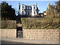
A villa in Station Road, Banchory
In a row of mid-19th century granite piles, with fine view south over the River Dee.
Image: © Stanley Howe
Taken: 20 Mar 2011
0.02 miles
2
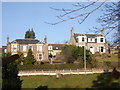
Houses on Station Road
Seen from Bellfield Park.
Image: © Stanley Howe
Taken: 21 Jan 2009
0.02 miles
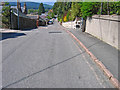
3
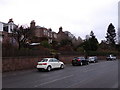
Street parking in Banchory
On Station Road (A93), opposite the park.
Image: © Stanley Howe
Taken: 22 Jan 2014
0.03 miles
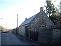
5
Elms Rise, Banchory
Lane joining Ramsay Road, Watson Street and Arbeadie Terrace.
Image: © Alan Findlay
Taken: 8 May 2008
0.05 miles
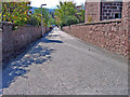
7
Driveway through Bellfield Park playing fields
Image: © Stanley Howe
Taken: 9 Sep 2015
0.06 miles
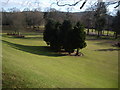
9
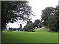
Bellfield Park, Banchory
Viewed from the east end.
Image: © Stanley Howe
Taken: 9 Sep 2015
0.06 miles
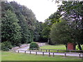
10
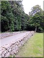
Driveway out of Bellfield Park
ENE towards Station Road (A93), Banchory.
Image: © Stanley Howe
Taken: 9 Sep 2015
0.06 miles