IMAGES TAKEN NEAR TO
Torphins, BANCHORY, AB31 4LE
Introduction
This page details the photographs taken nearby to AB31 4LE by members of the Geograph project.
The Geograph project started in 2005 with the aim of publishing, organising and preserving representative images for every square kilometre of Great Britain, Ireland and the Isle of Man.

There are currently over 7.5m images from over14,400 individuals and you can help contribute to the project by visiting https://www.geograph.org.uk
Image Map
Images are licensed for reuse under creativecommons.org/licenses/by-sa/2.0
Notes
- Clicking on the map will re-center to the selected point.
- The higher the marker number, the further away the image location is from the centre of the postcode.
Image Listing (22 Images Found)
Images are licensed for reuse under creativecommons.org/licenses/by-sa/2.0
Image
Details
Distance
1
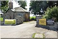
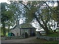
Findrack Lodge
Scotland Gardens Scheme open day, July 2018.
Image: © Stanley Howe
Taken: 22 Jul 2018
0.00 miles
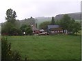
2
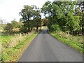
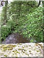
Road and bridge crossing Beltie Burn near to Dubs
Looking south-westward.
Image: © Peter Wood
Taken: 13 Oct 2019
0.02 miles
3
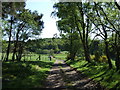
View towards Tornaveen
From the track to Hillhead.
Image: © Stanley Howe
Taken: 21 May 2007
0.04 miles
4
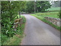
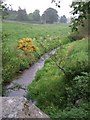
Bridge over the Burn of Ennets
Looking towards Findrack from Tornaveen.
Image: © Stanley Howe
Taken: 17 Jun 2007
0.05 miles
10
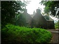
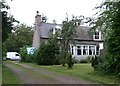
Tornaveen House
Another clan Fraser dwelling.
Image: © Stanley Howe
Taken: 28 Aug 2005
0.14 miles