IMAGES TAKEN NEAR TO
BANCHORY, AB31 4AT
Introduction
This page details the photographs taken nearby to AB31 4AT by members of the Geograph project.
The Geograph project started in 2005 with the aim of publishing, organising and preserving representative images for every square kilometre of Great Britain, Ireland and the Isle of Man.

There are currently over 7.5m images from over14,400 individuals and you can help contribute to the project by visiting https://www.geograph.org.uk
Image Map
Images are licensed for reuse under creativecommons.org/licenses/by-sa/2.0
Notes
- Clicking on the map will re-center to the selected point.
- The higher the marker number, the further away the image location is from the centre of the postcode.
Image Listing (17 Images Found)
Images are licensed for reuse under creativecommons.org/licenses/by-sa/2.0
Image
Details
Distance
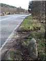
1
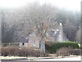
Cottages by Burn of Canny
From Craiglash Road near its junction with A93.
Image: © Stanley Howe
Taken: 28 Feb 2009
0.02 miles
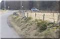
2

Junction off A93 for Craiglash Quarry
Near Bridge of Canny. Once this was the main North Deeside Road.
Image: © Stanley Howe
Taken: 20 Aug 1986
0.06 miles
3
Bridge of Canny
On A93, seen from Craiglash junction.
Image: © Stanley Howe
Taken: 28 Feb 2009
0.06 miles
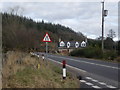
4
Junction of Craiglash Road with A93
At Bridge of Canny.
Image: © Stanley Howe
Taken: 28 Feb 2009
0.07 miles
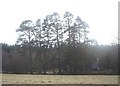
7
Cottage by Craiglash Junction, Bridge of Canny
Image: © Stanley Howe
Taken: 28 Feb 2009
0.11 miles
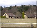
8

A cottage between A93 and Bogloch Burn
Near Bridge of Canny.
Image: © Stanley Howe
Taken: 28 Feb 2009
0.13 miles
9
Cottages between Bogloch Burn and A93
From Craiglash Road.
Image: © Stanley Howe
Taken: 28 Feb 2009
0.13 miles