IMAGES TAKEN NEAR TO
Ironside View, AB30 1JF
Introduction
This page details the photographs taken nearby to Ironside View, AB30 1JF by members of the Geograph project.
The Geograph project started in 2005 with the aim of publishing, organising and preserving representative images for every square kilometre of Great Britain, Ireland and the Isle of Man.

There are currently over 7.5m images from over14,400 individuals and you can help contribute to the project by visiting https://www.geograph.org.uk
Image Map
Images are licensed for reuse under creativecommons.org/licenses/by-sa/2.0
Notes
- Clicking on the map will re-center to the selected point.
- The higher the marker number, the further away the image location is from the centre of the postcode.
Image Listing (7 Images Found)
Images are licensed for reuse under creativecommons.org/licenses/by-sa/2.0
Image
Details
Distance
1
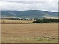
Stubble near Laurencekirk
Looking over stubble and already ploughed land near Laurencekirk towards Strathfinella Hill
Image: © Richard Webb
Taken: 6 Aug 2011
0.12 miles
4
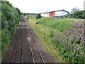
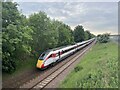
Rail track south from Blackiemuir Avenue bridge
UP-line from Aberdeen to Edinburgh/Glasgow via Laurencekirk. The large building on the right is a recently built NHS Medical Resource Centre.
Image: © Stanley Howe
Taken: 12 Jul 2017
0.18 miles
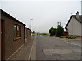
5
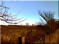
Gaugers Burn bankside and across fields to Laurencekirk
Image: © Penni Currie
Taken: 21 Feb 2005
0.22 miles
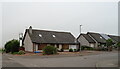
6
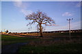
Laurencekirk in the distance
From the Denlethen Wood road.
Image: © david shaw
Taken: 23 Dec 2005
0.22 miles