IMAGES TAKEN NEAR TO
Skene Square, ABERDEEN, AB25 2UN
Introduction
This page details the photographs taken nearby to Skene Square, AB25 2UN by members of the Geograph project.
The Geograph project started in 2005 with the aim of publishing, organising and preserving representative images for every square kilometre of Great Britain, Ireland and the Isle of Man.

There are currently over 7.5m images from over14,400 individuals and you can help contribute to the project by visiting https://www.geograph.org.uk
Image Map (Loading...)


Getting Data...Please wait
Leaflet Map data © OpenStreetMap
Images are licensed for reuse under creativecommons.org/licenses/by-sa/2.0
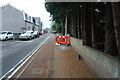
Notes
- Clicking on the map will re-center to the selected point.
- The higher the marker number, the further away the image location is from the centre of the postcode.
Image Listing (124 Images Found)
Images are licensed for reuse under creativecommons.org/licenses/by-sa/2.0
Image
Details
Distance
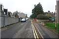
2
Turf Zone "DonaldsPlace"
Forbes Road, Aberdeen.
Image: © Ian S
Taken: 4 Oct 2022
0.03 miles
3
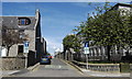
A look down Forbes Street...
... with a small corner of Skene Square Primary School to the right.
Image: © Bill Harrison
Taken: 3 Aug 2012
0.06 miles
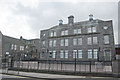
4
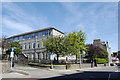
Skene Square Primary School (view from Rosemount Place)
Another example of the massive, granite, three-storey design of Aberdeen primary schools of the early 1900s [compare Kittybrewster http://www.geograph.org.uk/photo/918013 , Hanover Street http://www.geograph.org.uk/photo/3017222 , Frederick Street (now closed) http://www.geograph.org.uk/photo/3017252 , Mile End (now closed) http://www.geograph.org.uk/photo/866076 and Causewayend (now closed) http://www.geograph.org.uk/photo/852307 ].
Image: © Bill Harrison
Taken: 3 Aug 2012
0.06 miles
5
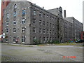
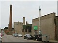
Broadford Works, Granite Mill.
This picture was taken after the Broadford Works closed. It shows the South mill in the foreground, The oldest part of the works.
Image: © George Wilson
Taken: 12 Jun 2006
0.07 miles
6
Storm brewing over Skene Square Primary School
One of several large granite buildings on the sprawling site. The date-stone on the chimney breast reads 1919.
Image: © Bill Harrison
Taken: 5 Oct 2008
0.07 miles
7
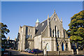
Clan Cancer Support Centre
Housed in the former Rosemount Parish Church with its unfinished tower and C-listed (see: http://www.britishlistedbuildings.co.uk/sc-19949-rosemount-church-c-of-s-rosemount-terrace ), the centre is threatened with demolition in the name of road "improvements."
Image: © Bill Harrison
Taken: 11 Oct 2008
0.08 miles
8
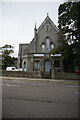
Christ Apostolic Church
On Caroline Place, Aberdeen.
Image: © Ian S
Taken: 4 Oct 2022
0.08 miles
9
Granite Cottages, Rosemount Place , Aberdeen
Image: © Bill Harrison
Taken: 3 Aug 2012
0.08 miles
10
Hutcheon Street, Aberdeen
Hutcheon Street in an industrial district near the centre of Aberdeen. The tall and ornate column in the foreground to the right is a sewer ventilation shaft. A second, similar ventilation shaft can be seen a short distance further along the street.
Image: © Malc McDonald
Taken: 29 Apr 2023
0.08 miles