IMAGES TAKEN NEAR TO
Summerfield Terrace, ABERDEEN, AB24 5JH
Introduction
This page details the photographs taken nearby to Summerfield Terrace, AB24 5JH by members of the Geograph project.
The Geograph project started in 2005 with the aim of publishing, organising and preserving representative images for every square kilometre of Great Britain, Ireland and the Isle of Man.

There are currently over 7.5m images from over14,400 individuals and you can help contribute to the project by visiting https://www.geograph.org.uk
Image Map
Images are licensed for reuse under creativecommons.org/licenses/by-sa/2.0
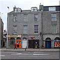
Notes
- Clicking on the map will re-center to the selected point.
- The higher the marker number, the further away the image location is from the centre of the postcode.
Image Listing (344 Images Found)
Images are licensed for reuse under creativecommons.org/licenses/by-sa/2.0
Image
Details
Distance
1
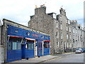
The Scotia Bar, Summerfield Terrace
Incongruous single-storey bar in a street of 4-5 storey granite tenement buildings in Aberdeen. Note the railings and the basement flats ("sunks"). The street still has its granite cassies (setts).
Image: © Colin Smith
Taken: 9 Apr 2007
0.01 miles
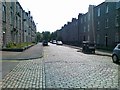
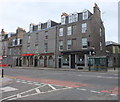
3
The Scotia Bar, Summerfield Terrace, Aberdeen
Note the junction prohibiting vehicles but leaving a "fire path" for emergency access.
Image: © Bill Harrison
Taken: 16 Aug 2014
0.05 miles
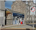
4
Ice cream parlour, King Street, Aberdeen
A welcome sight for a foot-sore Geographer or indeed anybody else...
Image: © Bill Harrison
Taken: 16 Aug 2014
0.06 miles
5
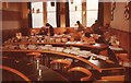
Council Chamber, Aberdeen University SRC
The Council Chamber of the Students' Representative Council at 151 King Street.
Members of Aberdeen Students Charities Campaign are packing and sorting envelopes with information for students about the forthcoming Charities Week to be sent out over the Easter holidays. Sorting the envelopes into postal areas was a very good way of learning where remote parts of Scotland (and beyond) were located.
Image: © Richard Sutcliffe
Taken: Unknown
0.06 miles
6
The East Neuk Bar, King Street, Aberdeen
Image: © Bill Harrison
Taken: 12 May 2013
0.06 miles
7
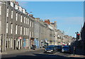
King Street, Aberdeen
The main road north towards Fraserburgh was laid out in about 1804 according to plans of Charles Abercrombie as an early example of town planning.
Image: © Bill Harrison
Taken: 1 Mar 2014
0.06 miles
8
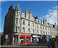
Washington Buildings, King Street, Aberdeen
Built around 1890 of hard-wearing granite and still in pristine condition. The tourelle (corner turret) pays homage to the Scottish baronial style.
Image: © Bill Harrison
Taken: 16 Aug 2014
0.07 miles
9
Bingo!
Bingo hall, Frederick Street, Aberdeen
Image: © Bill Harrison
Taken: 30 Jun 2012
0.07 miles
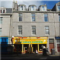
10
Tattoo and body piercing parlours, King Street
No comment, really...
Image: © Bill Harrison
Taken: 12 May 2013
0.07 miles