IMAGES TAKEN NEAR TO
Park Road, ABERDEEN, AB24 5AU
Introduction
This page details the photographs taken nearby to Park Road, AB24 5AU by members of the Geograph project.
The Geograph project started in 2005 with the aim of publishing, organising and preserving representative images for every square kilometre of Great Britain, Ireland and the Isle of Man.

There are currently over 7.5m images from over14,400 individuals and you can help contribute to the project by visiting https://www.geograph.org.uk
Image Map
Images are licensed for reuse under creativecommons.org/licenses/by-sa/2.0
Notes
- Clicking on the map will re-center to the selected point.
- The higher the marker number, the further away the image location is from the centre of the postcode.
Image Listing (56 Images Found)
Images are licensed for reuse under creativecommons.org/licenses/by-sa/2.0
Image
Details
Distance
1
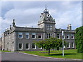
Aberdeen - City Hospital
Impressive range of granite buildings facing on to Urquhart Road. Building began here in 1874 following smallpox outbreaks in the city.
Image: © Colin Smith
Taken: 25 Jul 2010
0.03 miles
2

Rhodesia Buildings, Urquhart Road, Aberdeen
The four-storey terrace has 1909 on the datestone.
Image: © Bill Harrison
Taken: 12 May 2013
0.10 miles
3
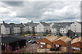
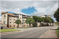
Apartments
Yet another huge apartment complex in this part of the city photographed from 'Miser's Hill', apparently so-called because it offered a glimpse of part of the pitch at Pittodrie Stadium, home of Aberdeen FC.
Image: © Bill Harrison
Taken: 13 Aug 2016
0.12 miles
4
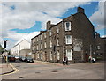
Corner block, Urquhart Road
Traditional granite block now surrounded by modern apartments.
Image: © Bill Harrison
Taken: 13 Aug 2016
0.12 miles
5
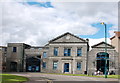
Satrosphere
The B-listed 'interactive science education centre' occupies former tram sheds, which in turn were converted from public swimming baths: http://www.britishlistedbuildings.co.uk/sc-49309-satrosphere-179-constitution-street-forme#.V-g1GSYVCmQ .
Image: © Bill Harrison
Taken: 13 Aug 2016
0.13 miles
6
Flats
A sprawling modern block on Links Road, which curves around onto Urquhart Road at the traffic lights in the distance.
Image: © Bill Harrison
Taken: 13 Aug 2016
0.13 miles
7

The former Aberdeen Tram Sheds
Now the home of the hands-on science Satrosphere.
Image: © Stanley Howe
Taken: 17 Oct 2007
0.14 miles
8

Satrosphere building
Hands-on Science Centre in Constitution Street. See http://www.satrosphere.net/
Image: © Stanley Howe
Taken: 17 Oct 2008
0.14 miles
9
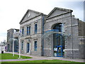
Satrosphere, Links Road
Science Museum, formerly located in Justice Mill Lane beside the Odeon. Today it is in one of the old Aberdeen Corporation Transport granite tram sheds. The other sheds were at Mannofield and at the northern end of Victoria Bridge.
Image: © Colin Smith
Taken: 9 Apr 2007
0.14 miles
10
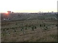
Aberdeen: Trinity Cemetery at sunset
An interesting view over the cemetery from the trig point.
Image: © Chris Downer
Taken: 20 Oct 2007
0.15 miles