IMAGES TAKEN NEAR TO
Hermitage Avenue, ABERDEEN, AB24 3LU
Introduction
This page details the photographs taken nearby to Hermitage Avenue, AB24 3LU by members of the Geograph project.
The Geograph project started in 2005 with the aim of publishing, organising and preserving representative images for every square kilometre of Great Britain, Ireland and the Isle of Man.

There are currently over 7.5m images from over14,400 individuals and you can help contribute to the project by visiting https://www.geograph.org.uk
Image Map
Images are licensed for reuse under creativecommons.org/licenses/by-sa/2.0
Notes
- Clicking on the map will re-center to the selected point.
- The higher the marker number, the further away the image location is from the centre of the postcode.
Image Listing (307 Images Found)
Images are licensed for reuse under creativecommons.org/licenses/by-sa/2.0
Image
Details
Distance
1
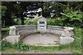
The Gibberie Wallie
This strange name possibly refers to a 17th Century 'gingerbread well (or wall)' although the structure itself only dates from 1937.
Image: © Bill Harrison
Taken: 12 Jun 2016
0.05 miles
3
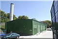
University of Aberdeen Heating Station
Image: © Bill Harrison
Taken: 29 May 2009
0.07 miles
4
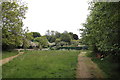
Urban wilderness
The under-maintained part of Sunnybank Park...
Image: © Bill Harrison
Taken: 12 Jun 2016
0.07 miles
5
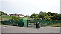
Secure allotments
Security paling fences are everywhere but it seems like overkill to surround allotments with one. Old Aberdeen Medical Centre is on the hillside behind.
Image: © Bill Harrison
Taken: 12 Jun 2016
0.07 miles
6
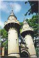
Former Powis Lodge Gatehouse, Old Aberdeen.
These "pepper pot" towers are on Old Aberdeen High Street, just south of Kings College, and lead into the Crombie / Johnston Halls of Residence for the varsity.
Image: © Colin Smith
Taken: 29 Jul 1996
0.07 miles
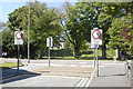
7
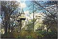
College Bounds, Old Aberdeen.
Taken from the grounds of Crombie & Johnston Halls. The towers are the former Powis Lodge gate. Kings College crown is visible to the right of the towers. The houses are on College Bounds which becomes High Street.
Image: © Colin Smith
Taken: Unknown
0.07 miles
9
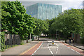
Bedford Road, Aberdeen
The large building ahead is Aberdeen University's new library.
Image: © Stephen McKay
Taken: 3 Jun 2012
0.08 miles
10
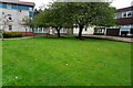
Turf Zone "CrombieHall"
At the University of Aberdeen.
Image: © Ian S
Taken: 5 Oct 2022
0.08 miles