IMAGES TAKEN NEAR TO
Panmure Gardens, ABERDEEN, AB23 8UG
Introduction
This page details the photographs taken nearby to Panmure Gardens, AB23 8UG by members of the Geograph project.
The Geograph project started in 2005 with the aim of publishing, organising and preserving representative images for every square kilometre of Great Britain, Ireland and the Isle of Man.

There are currently over 7.5m images from over14,400 individuals and you can help contribute to the project by visiting https://www.geograph.org.uk
Image Map
Images are licensed for reuse under creativecommons.org/licenses/by-sa/2.0
Notes
- Clicking on the map will re-center to the selected point.
- The higher the marker number, the further away the image location is from the centre of the postcode.
Image Listing (14 Images Found)
Images are licensed for reuse under creativecommons.org/licenses/by-sa/2.0
Image
Details
Distance
2
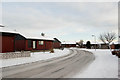
Chalets
Part of a large estate of chalet-like homes.
Image: © Bill Harrison
Taken: 20 Dec 2009
0.08 miles
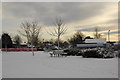
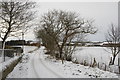
4
Potterton manse and kirk
The manse is now a private dwelling and the services in the kirk are administered by the Congregationalist Church. For the surprisingly turbulent history of the building, see:http://www.belhelvie.org.uk/history/kirks.htm
The bizarre road sign seems to direct cars onto the pavement.
Image: © Bill Harrison
Taken: 20 Dec 2009
0.12 miles
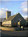
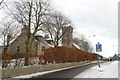
6
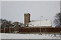
Potterton Kirk
Surprisingly, the OS map does not show the building.
Image: © Bill Harrison
Taken: 20 Dec 2009
0.12 miles
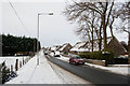
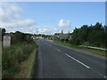
7
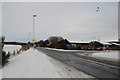
Junction of Kirkhill Road with the B999, Potterton
Image: © Bill Harrison
Taken: 20 Dec 2009
0.14 miles