IMAGES TAKEN NEAR TO
Keir Rise, ABERDEEN, AB23 8TW
Introduction
This page details the photographs taken nearby to Keir Rise, AB23 8TW by members of the Geograph project.
The Geograph project started in 2005 with the aim of publishing, organising and preserving representative images for every square kilometre of Great Britain, Ireland and the Isle of Man.

There are currently over 7.5m images from over14,400 individuals and you can help contribute to the project by visiting https://www.geograph.org.uk
Image Map
Images are licensed for reuse under creativecommons.org/licenses/by-sa/2.0
Notes
- Clicking on the map will re-center to the selected point.
- The higher the marker number, the further away the image location is from the centre of the postcode.
Image Listing (7 Images Found)
Images are licensed for reuse under creativecommons.org/licenses/by-sa/2.0
Image
Details
Distance
4
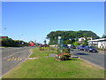
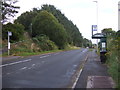
Old Road, Balmedie
Balmedie is a commuter village to the north of Aberdeen. The vast majority of houses have been built since the 1970s. This picture shows the main road through the village. The Aberdeen to Peterhead bus service stops here. To the right the White Horse Inn can be seen.
Image: © Richard Slessor
Taken: 20 Aug 2005
0.17 miles
5
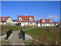
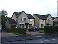
New houses at Balmedie
These houses by the Eigie burn are so new (built around 2004) that they don't appear on the map yet.
Image: © Richard Slessor
Taken: 29 Mar 2006
0.17 miles
6
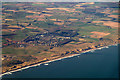
Balmedie from the air
Taken from a plane just after take-off from Aberdeen Airport.
Image: © Mike Pennington
Taken: 27 Feb 2017
0.17 miles