IMAGES TAKEN NEAR TO
Bridge Of Don, ABERDEEN, AB23 8NN
Introduction
This page details the photographs taken nearby to AB23 8NN by members of the Geograph project.
The Geograph project started in 2005 with the aim of publishing, organising and preserving representative images for every square kilometre of Great Britain, Ireland and the Isle of Man.

There are currently over 7.5m images from over14,400 individuals and you can help contribute to the project by visiting https://www.geograph.org.uk
Image Map
Images are licensed for reuse under creativecommons.org/licenses/by-sa/2.0
Notes
- Clicking on the map will re-center to the selected point.
- The higher the marker number, the further away the image location is from the centre of the postcode.
Image Listing (7 Images Found)
Images are licensed for reuse under creativecommons.org/licenses/by-sa/2.0
Image
Details
Distance
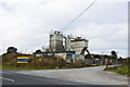
1
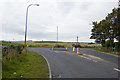
Rural Roundabout
This seems like over-provision at the junction of two country lanes.
Image: © Bill Harrison
Taken: 19 Sep 2009
0.13 miles
3
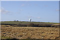
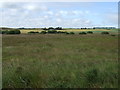
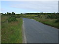
Perwinnes Moss
Radar Station for Aberdeen Airport in the distance
Image: © Bill Harrison
Taken: 27 Feb 2011
0.19 miles
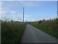
4
Rural road heading east, Perwinnes Moss
Towards Shielhill.
Image: © JThomas
Taken: 18 Jul 2014
0.22 miles
6
Minor road heading north
Towards Newtonhill.
Image: © JThomas
Taken: 18 Jul 2014
0.23 miles