IMAGES TAKEN NEAR TO
Daisy Road, AB23 8HF
Introduction
This page details the photographs taken nearby to Daisy Road, AB23 8HF by members of the Geograph project.
The Geograph project started in 2005 with the aim of publishing, organising and preserving representative images for every square kilometre of Great Britain, Ireland and the Isle of Man.

There are currently over 7.5m images from over14,400 individuals and you can help contribute to the project by visiting https://www.geograph.org.uk
Image Map
Images are licensed for reuse under creativecommons.org/licenses/by-sa/2.0
Notes
- Clicking on the map will re-center to the selected point.
- The higher the marker number, the further away the image location is from the centre of the postcode.
Image Listing (12 Images Found)
Images are licensed for reuse under creativecommons.org/licenses/by-sa/2.0
Image
Details
Distance
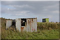
2
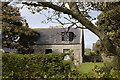
Cottage
In the classical Aberdeen granite style.
Image: © Bill Harrison
Taken: 19 Sep 2009
0.12 miles
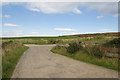
5
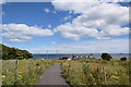
Heading for Blackdog beach
The new path seems to be associated with the substation for the offshore wind turbines visible in the distance.
Image: © Bill Harrison
Taken: 18 Jul 2020
0.15 miles
7
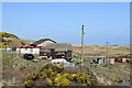
Willowgrove Farmstead...
...with coastal dunes behind and a glimpse of the sea.
Image: © Bill Harrison
Taken: 3 Apr 2021
0.18 miles
9
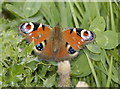
Peacock
This poor butterfly was ailing in the chill autumn breeze...
Image: © Bill Harrison
Taken: 19 Sep 2009
0.19 miles
10
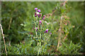
Thistle
Scotland's national flower grows in abundance in this square.
Image: © Bill Harrison
Taken: 19 Sep 2009
0.20 miles