IMAGES TAKEN NEAR TO
Bridge Of Don, ABERDEEN, AB23 8BQ
Introduction
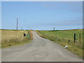
This page details the photographs taken nearby to AB23 8BQ by members of the Geograph project.
The Geograph project started in 2005 with the aim of publishing, organising and preserving representative images for every square kilometre of Great Britain, Ireland and the Isle of Man.

There are currently over 7.5m images from over14,400 individuals and you can help contribute to the project by visiting https://www.geograph.org.uk
Image Map
Images are licensed for reuse under creativecommons.org/licenses/by-sa/2.0
Notes
- Clicking on the map will re-center to the selected point.
- The higher the marker number, the further away the image location is from the centre of the postcode.
Image Listing (4 Images Found)
Images are licensed for reuse under creativecommons.org/licenses/by-sa/2.0
Image
Details
Distance
1
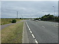
A90 Aberdeen to Peterhead Road
This photo of the main road between two of the largest towns in N.E. Scotland, virtually free of traffic, was taken at 2:30pm.
Image: © Richard Slessor
Taken: 16 Mar 2005
0.13 miles