IMAGES TAKEN NEAR TO
Ardross Street, ABERDEEN, AB22 9AL
Introduction
This page details the photographs taken nearby to Ardross Street, AB22 9AL by members of the Geograph project.
The Geograph project started in 2005 with the aim of publishing, organising and preserving representative images for every square kilometre of Great Britain, Ireland and the Isle of Man.

There are currently over 7.5m images from over14,400 individuals and you can help contribute to the project by visiting https://www.geograph.org.uk
Image Map
Images are licensed for reuse under creativecommons.org/licenses/by-sa/2.0
Notes
- Clicking on the map will re-center to the selected point.
- The higher the marker number, the further away the image location is from the centre of the postcode.
Image Listing (9 Images Found)
Images are licensed for reuse under creativecommons.org/licenses/by-sa/2.0
Image
Details
Distance
4
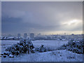
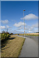
The Granite City
A supplemental shot of Aberdeen
Image: © Graham Scott
Taken: 29 Dec 2005
0.18 miles
6
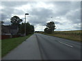
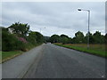
Whitestripes Road
Escape to the countryside...
Image: © Bill Harrison
Taken: 11 Oct 2009
0.20 miles
7
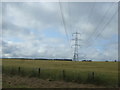
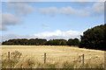
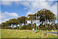
Crop field and power lines, Danestone
North of the A90.
Image: © JThomas
Taken: 18 Jul 2014
0.22 miles