IMAGES TAKEN NEAR TO
Woodcroft Gardens, ABERDEEN, AB22 8DT
Introduction
This page details the photographs taken nearby to Woodcroft Gardens, AB22 8DT by members of the Geograph project.
The Geograph project started in 2005 with the aim of publishing, organising and preserving representative images for every square kilometre of Great Britain, Ireland and the Isle of Man.

There are currently over 7.5m images from over14,400 individuals and you can help contribute to the project by visiting https://www.geograph.org.uk
Image Map
Images are licensed for reuse under creativecommons.org/licenses/by-sa/2.0
Notes
- Clicking on the map will re-center to the selected point.
- The higher the marker number, the further away the image location is from the centre of the postcode.
Image Listing (10 Images Found)
Images are licensed for reuse under creativecommons.org/licenses/by-sa/2.0
Image
Details
Distance
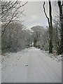
2

Clear-felling with beech trees behind
Image: © Bill Harrison
Taken: 25 Apr 2020
0.19 miles

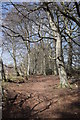

6

Beech walk
The dome of Perwinnes Hill Radar Station can be glimpsed in the distance.
Image: © Bill Harrison
Taken: 25 Apr 2020
0.23 miles
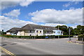
8
Suburban shopping parade
From left-to-right: beauty salon, vacant (formerly a Lebanese takeaway), aquarium supplies, fish and chip shop ('chipper' in Scottish). The centre is "anchored" by the Co-op convenience store around the corner to the left.
Image: © Bill Harrison
Taken: 6 Jun 2020
0.24 miles
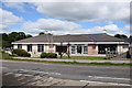
9

Forehill Primary School, Aberdeen
School roll: approximately 210. The grass is a bit shaggy in the coronavirus crisis of 2020.
Image: © Bill Harrison
Taken: 6 Jun 2020
0.24 miles
10
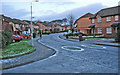
Ashwood Road
Typical housing in the Ashwood or Causewayend area. One of the very last streets in the city before the countryside.
Image: © Graham Scott
Taken: 29 Nov 2005
0.25 miles