IMAGES TAKEN NEAR TO
Granitehill Terrace, ABERDEEN, AB22 8AT
Introduction
This page details the photographs taken nearby to Granitehill Terrace, AB22 8AT by members of the Geograph project.
The Geograph project started in 2005 with the aim of publishing, organising and preserving representative images for every square kilometre of Great Britain, Ireland and the Isle of Man.

There are currently over 7.5m images from over14,400 individuals and you can help contribute to the project by visiting https://www.geograph.org.uk
Image Map
Images are licensed for reuse under creativecommons.org/licenses/by-sa/2.0
Notes
- Clicking on the map will re-center to the selected point.
- The higher the marker number, the further away the image location is from the centre of the postcode.
Image Listing (13 Images Found)
Images are licensed for reuse under creativecommons.org/licenses/by-sa/2.0
Image
Details
Distance
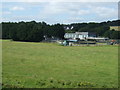
2
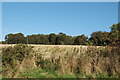
Autumn Fields
Just a few hundred metres from a giant supermarket and suburbia...
Image: © Bill Harrison
Taken: 3 Oct 2009
0.10 miles
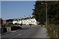
6
Stop a traffic line
A queue on Mugiemoss Road. The area was very congested in the late afternoon.
Image: © Richard Webb
Taken: 3 Aug 2011
0.21 miles
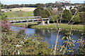
8
Farmland and water treatment works near the River Don
Image: © JThomas
Taken: 18 Jul 2014
0.22 miles
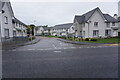
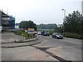
9
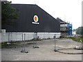
Mugiemoss Road
New residential buildings under construction; the area seems to be in a state of deindustrialisation.
Image: © Richard Webb
Taken: 3 Aug 2011
0.22 miles
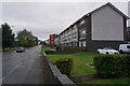
10
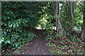
Turf Zone "NowYouveDonit"
Riverside path off Laurel Drive, Aberdeen.
Image: © Ian S
Taken: 5 Oct 2022
0.24 miles