IMAGES TAKEN NEAR TO
AB21 0XJ
Introduction
This page details the photographs taken nearby to AB21 0XJ by members of the Geograph project.
The Geograph project started in 2005 with the aim of publishing, organising and preserving representative images for every square kilometre of Great Britain, Ireland and the Isle of Man.

There are currently over 7.5m images from over14,400 individuals and you can help contribute to the project by visiting https://www.geograph.org.uk
Image Map
Images are licensed for reuse under creativecommons.org/licenses/by-sa/2.0
Notes
- Clicking on the map will re-center to the selected point.
- The higher the marker number, the further away the image location is from the centre of the postcode.
Image Listing (9 Images Found)
Images are licensed for reuse under creativecommons.org/licenses/by-sa/2.0
Image
Details
Distance
3
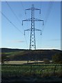
Farmland and power lines
Towards the River Don.
Image: © JThomas
Taken: 9 Nov 2013
0.11 miles
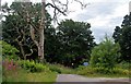
5
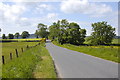
Tree at Newmachar road junction
A tree marks the B979 road junction
Image: © Andrew Wood
Taken: 11 Oct 2008
0.19 miles
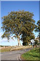
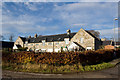
6
Lammington Court
A group of houses, probably redeveloped former farm buildings.
Image: © John Allan
Taken: 6 Feb 2007
0.21 miles
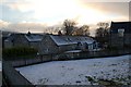
7
Lamington Court
An unusual location, possibly converted farm buildings.
Image: © Bill Harrison
Taken: 15 Nov 2009
0.22 miles