IMAGES TAKEN NEAR TO
Mameulah Crescent, ABERDEEN, AB21 0WG
Introduction
This page details the photographs taken nearby to Mameulah Crescent, AB21 0WG by members of the Geograph project.
The Geograph project started in 2005 with the aim of publishing, organising and preserving representative images for every square kilometre of Great Britain, Ireland and the Isle of Man.

There are currently over 7.5m images from over14,400 individuals and you can help contribute to the project by visiting https://www.geograph.org.uk
Image Map
Images are licensed for reuse under creativecommons.org/licenses/by-sa/2.0
Notes
- Clicking on the map will re-center to the selected point.
- The higher the marker number, the further away the image location is from the centre of the postcode.
Image Listing (19 Images Found)
Images are licensed for reuse under creativecommons.org/licenses/by-sa/2.0
Image
Details
Distance
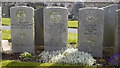
1
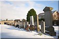
Where Heroes Lie Sleeping
War graves under a layer of snow at Newmachar Cemetery. See http://www.cwgc.org/search/cemetery_details.aspx?cemetery=34169&mode=1 for some details about the servicemen buried here.
Image: © Andrew Wood
Taken: 22 Nov 2008
0.10 miles
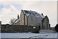
2
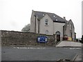
New Machar Parish Church
School Road, Newmachar.
Image: © Richard Webb
Taken: 3 Aug 2011
0.13 miles
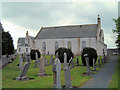
4
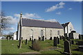
Newmachar Kirk
Part of the Church of Scotland. For the church website, see: http://www.newmacharchurch.net/
Image: © Bill Harrison
Taken: 18 Mar 2012
0.14 miles
5
Will we remember them?
War graves at Newmachar Cemetery including an unusual "double" grave. Most of those buried at Newmachar lost their lives in a naval disaster in 1942. The St Briac was a cross-channel ferry commandeered for Naval Auxiliary Patrol (NAP) work on the eastern Scottish coast. On March 12 1942, a storm forced the ship onto a (British) minefield and the ship sank after hitting a mine. Lifeboats were launched, but most of them were lost in the storm and a total of 47 men died. For more, see: http://www.bobleroi.co.uk/ScrapBook/OldShips/StBriac.pdf
and http://www.scotsman.com/news/wreck_of_the_st_briac_the_forgotten_sacrifice_1_1146074
Image: © Bill Harrison
Taken: 28 Apr 2012
0.14 miles
7
Newmachar Church
Looking a little festive with a fresh snowfall the parish church of Newmachar.
Image: © Andrew Wood
Taken: 22 Nov 2008
0.16 miles
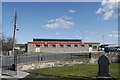
9
Newmachar Primary School
The typical Aberdeenshire granite school building has been massively expanded to accommodate the ever-increasing school roll (370 according to the school website).
Image: © Bill Harrison
Taken: 18 Mar 2012
0.17 miles
10
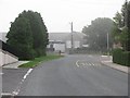
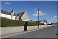
Newmachar new builds
Like a number of villages near Aberdeen, Newmachar is growing rapidly. School Road (centre of the picture) heads towards the village centre. The road running left-to-right (somewhat redundantly called Hillbrae Way, where Brae is Scottish for hillside) marks the present edge of development.
Image: © Bill Harrison
Taken: 18 Mar 2012
0.19 miles