IMAGES TAKEN NEAR TO
Stewart Crescent, ABERDEEN, AB16 5SR
Introduction
This page details the photographs taken nearby to Stewart Crescent, AB16 5SR by members of the Geograph project.
The Geograph project started in 2005 with the aim of publishing, organising and preserving representative images for every square kilometre of Great Britain, Ireland and the Isle of Man.

There are currently over 7.5m images from over14,400 individuals and you can help contribute to the project by visiting https://www.geograph.org.uk
Image Map
Images are licensed for reuse under creativecommons.org/licenses/by-sa/2.0
Notes
- Clicking on the map will re-center to the selected point.
- The higher the marker number, the further away the image location is from the centre of the postcode.
Image Listing (20 Images Found)
Images are licensed for reuse under creativecommons.org/licenses/by-sa/2.0
Image
Details
Distance
1
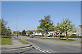
Provost Fraser Drive, Aberdeen
Looking westwards. Provost Fraser Drive is the cut-off between Mastrick (to the south) and Northfield (to the north).
Image: © Bill Harrison
Taken: 30 Apr 2011
0.12 miles
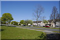
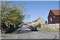
3
Tay Road, Mastrick, Aberdeen
Upper Mastrick Way in the foreground.
Image: © Bill Harrison
Taken: 30 Apr 2011
0.15 miles
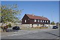
4
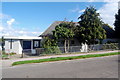
Byron Park sheltered housing, Northfield
This immaculate little grouping (although the satellite dishes and wheelie bins do nothing to help appearances) modeled on Almshouses seems to date from earlier that the 1960s, when most of Northfield estate was built. Any further information would be welcome.
Image: © Bill Harrison
Taken: 20 Sep 2014
0.15 miles
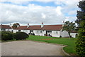
6
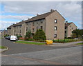
Council flats, Deansloch Place, Northfield
The blocks face onto Deansloch Place. At the back is a drying green and play space. The dingy brown rendering does nothing for their appearance...
Image: © Bill Harrison
Taken: 20 Sep 2014
0.17 miles
7
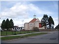
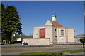
Northfield United Free Church, Deansloch Crescent, Northfield
For more about the UF church, see: https://en.wikipedia.org/wiki/United_Free_Church_of_Scotland .
Image: © Bill Harrison
Taken: 20 Sep 2014
0.17 miles
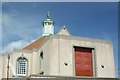
9
Holy Family (Roman Catholic) Church, Upper Mastrick Way, Aberdeen
For the church website, see: http://www.dioceseofaberdeen.org/index.php/parishes/city-of-aberdeen/mastrick
Image: © Bill Harrison
Taken: 30 Apr 2011
0.18 miles
10
Looking down Tay Road, Mastrick, Aberdeen
Image: © Bill Harrison
Taken: 30 Apr 2011
0.19 miles