IMAGES TAKEN NEAR TO
Kingswells, ABERDEEN, AB15 8ST
Introduction
This page details the photographs taken nearby to AB15 8ST by members of the Geograph project.
The Geograph project started in 2005 with the aim of publishing, organising and preserving representative images for every square kilometre of Great Britain, Ireland and the Isle of Man.

There are currently over 7.5m images from over14,400 individuals and you can help contribute to the project by visiting https://www.geograph.org.uk
Image Map
Images are licensed for reuse under creativecommons.org/licenses/by-sa/2.0
Notes
- Clicking on the map will re-center to the selected point.
- The higher the marker number, the further away the image location is from the centre of the postcode.
Image Listing (4 Images Found)
Images are licensed for reuse under creativecommons.org/licenses/by-sa/2.0
Image
Details
Distance
2
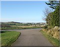
Road from Auchlea
With a view over Cadgerford farm to Arnhill Industrial Estate.
Image: © Stanley Howe
Taken: 16 Nov 2007
0.17 miles
3
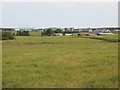
Field, Cadgerford
Cadgerford is named in a slightly different typeface by the Ordnance Survey, suggesting a new addition to the map. Also new is Westhill, totally absent from my paper copy of 1:50000 sheet 38. Some of the industrial estates can be seen in the background.
Image: © Richard Webb
Taken: 14 Jul 2013
0.21 miles
4
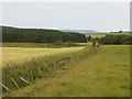
Drain near Auchlea
Silage has been taken off the field to the left and there is a view of the Hill of Fare.
Image: © Richard Webb
Taken: 14 Jul 2013
0.22 miles