IMAGES TAKEN NEAR TO
Kingswells, ABERDEEN, AB15 8PX
Introduction
This page details the photographs taken nearby to AB15 8PX by members of the Geograph project.
The Geograph project started in 2005 with the aim of publishing, organising and preserving representative images for every square kilometre of Great Britain, Ireland and the Isle of Man.

There are currently over 7.5m images from over14,400 individuals and you can help contribute to the project by visiting https://www.geograph.org.uk
Image Map
Images are licensed for reuse under creativecommons.org/licenses/by-sa/2.0
Notes
- Clicking on the map will re-center to the selected point.
- The higher the marker number, the further away the image location is from the centre of the postcode.
Image Listing (3 Images Found)
Images are licensed for reuse under creativecommons.org/licenses/by-sa/2.0
Image
Details
Distance
1
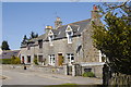
Granite cottages, Old Skene Road
The A944 dual carriageway now passes about 100 metres to the south.
Image: © Bill Harrison
Taken: 30 Apr 2011
0.20 miles
3
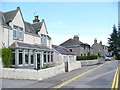
Old Skene Road
This was once the main road between Aberdeen and Skene. Today it is a dead end, by-passed by the dual carriageway to the south which caters for commuters living in expanded and new settlements like Westhill.
Image: © Colin Smith
Taken: 7 Aug 2009
0.22 miles