IMAGES TAKEN NEAR TO
Concraig Gardens, ABERDEEN, AB15 8LG
Introduction
This page details the photographs taken nearby to Concraig Gardens, AB15 8LG by members of the Geograph project.
The Geograph project started in 2005 with the aim of publishing, organising and preserving representative images for every square kilometre of Great Britain, Ireland and the Isle of Man.

There are currently over 7.5m images from over14,400 individuals and you can help contribute to the project by visiting https://www.geograph.org.uk
Image Map
Images are licensed for reuse under creativecommons.org/licenses/by-sa/2.0
Notes
- Clicking on the map will re-center to the selected point.
- The higher the marker number, the further away the image location is from the centre of the postcode.
Image Listing (22 Images Found)
Images are licensed for reuse under creativecommons.org/licenses/by-sa/2.0
Image
Details
Distance
1
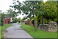
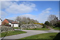
Consumption dyke, Kingswells
For more, see: https://www.geograph.org.uk/photo/6450468 .
Image: © Bill Harrison
Taken: 18 Apr 2020
0.04 miles
2
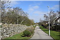
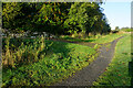
Walking beside the consumption dyke, Kingswells
Image: © Bill Harrison
Taken: 18 Apr 2020
0.04 miles
3
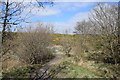
Walking beside the Bucks Burn
Daily exercise in the coronavirus crisis (April 2020).
Image: © Bill Harrison
Taken: 18 Apr 2020
0.05 miles
4
Consumption Dyce, Kingswells
Kingswells most distinctive feature is surely the 'consumption dyke' (also known as Rough's Cairn), which was created during agricultural improvements in the 19th Century when vast amounts of rocks and boulders were removed from neighbouring fields and 'consumed' into the enormous dry stane dyke, which is about 90 metres long, 6 metres high and 6 metres wide. See Canmore record 19338 for more: https://canmore.org.uk/site/19338/kingswells-roughs-cairn-consumption-dyke .
Image: © Bill Harrison
Taken: 18 Apr 2020
0.07 miles
5
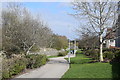
Turf Zone "WithGraig"
Path leading to Kingswells Crescent.
Image: © Ian S
Taken: 6 Oct 2022
0.08 miles
6
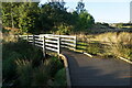
Approaching the bridge over Bucks Burn
Image: © Bill Harrison
Taken: 18 Apr 2020
0.10 miles
8
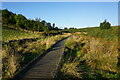
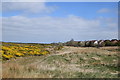
Turf Zone "BBValleyWalk"
Path on Burnbrae Moss.
Image: © Ian S
Taken: 6 Oct 2022
0.13 miles
9
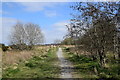
Bucks Burn valley path
A small part of many kilometres of attractive paths and trails that link Kingswells with Aberdeen's western suburbs.
Image: © Bill Harrison
Taken: 18 Apr 2020
0.14 miles