IMAGES TAKEN NEAR TO
Wellside Wynd, ABERDEEN, AB15 8EZ
Introduction
This page details the photographs taken nearby to Wellside Wynd, AB15 8EZ by members of the Geograph project.
The Geograph project started in 2005 with the aim of publishing, organising and preserving representative images for every square kilometre of Great Britain, Ireland and the Isle of Man.

There are currently over 7.5m images from over14,400 individuals and you can help contribute to the project by visiting https://www.geograph.org.uk
Image Map
Images are licensed for reuse under creativecommons.org/licenses/by-sa/2.0
Notes
- Clicking on the map will re-center to the selected point.
- The higher the marker number, the further away the image location is from the centre of the postcode.
Image Listing (24 Images Found)
Images are licensed for reuse under creativecommons.org/licenses/by-sa/2.0
Image
Details
Distance

3
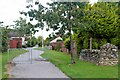
Turf Zone "KingsCrescent"
Path off Kingswells Crescent, Kingswells.
Image: © Ian S
Taken: 6 Oct 2022
0.07 miles
4

Supporting stones
Stones painted with messages of support for care workers during the coronavirus crisis (April 2020).
Image: © Bill Harrison
Taken: 18 Apr 2020
0.07 miles
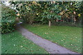
5
Bucks Burn valley path
A small part of many kilometres of attractive paths and trails that link Kingswells with Aberdeen's western suburbs.
Image: © Bill Harrison
Taken: 18 Apr 2020
0.07 miles
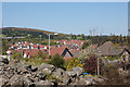
9
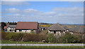
Looking north over Kingswells
Newhills Parish Kirk can just be seen in the distance, some 2 km away.
Image: © Bill Harrison
Taken: 18 Apr 2020
0.10 miles
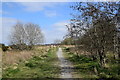
10
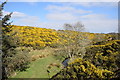
Bucks Burn and gorse
The source of Bucks Burn appears to be a small lake about 1 km to the south east; the burn joins the River Don at Bucksburn some 4 km downstream.
Image: © Bill Harrison
Taken: 18 Apr 2020
0.10 miles