IMAGES TAKEN NEAR TO
Airyhall Avenue, ABERDEEN, AB15 7QW
Introduction
This page details the photographs taken nearby to Airyhall Avenue, AB15 7QW by members of the Geograph project.
The Geograph project started in 2005 with the aim of publishing, organising and preserving representative images for every square kilometre of Great Britain, Ireland and the Isle of Man.

There are currently over 7.5m images from over14,400 individuals and you can help contribute to the project by visiting https://www.geograph.org.uk
Image Map
Images are licensed for reuse under creativecommons.org/licenses/by-sa/2.0
Notes
- Clicking on the map will re-center to the selected point.
- The higher the marker number, the further away the image location is from the centre of the postcode.
Image Listing (10 Images Found)
Images are licensed for reuse under creativecommons.org/licenses/by-sa/2.0
Image
Details
Distance
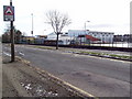
2
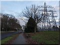
Countesswells Road and electricity substation
The picture looks East along Countesswells Road as it heads into Aberdeen, passing a large electricity substation.
Image: © Alec MacKinnon
Taken: 27 Dec 2012
0.19 miles
3
The new Airyhall Primary School
Airyhall Primary was recently rebuilt under the 3Rs public-private parnership.
Image: © Ewen Rennie
Taken: 1 Apr 2010
0.21 miles
5
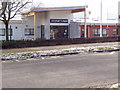
Entrance to the new Airyhall Primary School
Image: © Ewen Rennie
Taken: 1 Apr 2010
0.22 miles
6
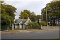
Lodge
The drive once led to the James Hutton Institute http://www.hutton.ac.uk/ , formerly known as the Macaulay Land Use Institute.
Image: © Bill Harrison
Taken: 8 Oct 2011
0.23 miles
7
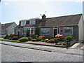
Housing in Craigiebuckler
Typical housing of the Braeside / Caigiebuckler area, Aberdeen
Image: © Lizzie
Taken: 15 May 2005
0.24 miles
8
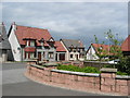
Modern estate, Craigiebuckler
New housing built in the original grounds of the Macaulay Institute
Image: © Lizzie
Taken: 15 May 2005
0.24 miles
9
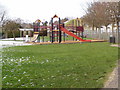
Play area by the old Braeside School
The old Braeside School is being used to rehouse schools being rebuilt under the 3Rs private-public partnership - firstly Airyhall and now Kaimhill.
Image: © Ewen Rennie
Taken: 1 Apr 2010
0.25 miles