IMAGES TAKEN NEAR TO
Towerview Road, PETERCULTER, AB14 0SE
Introduction
This page details the photographs taken nearby to Towerview Road, AB14 0SE by members of the Geograph project.
The Geograph project started in 2005 with the aim of publishing, organising and preserving representative images for every square kilometre of Great Britain, Ireland and the Isle of Man.

There are currently over 7.5m images from over14,400 individuals and you can help contribute to the project by visiting https://www.geograph.org.uk
Image Map
Images are licensed for reuse under creativecommons.org/licenses/by-sa/2.0
Notes
- Clicking on the map will re-center to the selected point.
- The higher the marker number, the further away the image location is from the centre of the postcode.
Image Listing (23 Images Found)
Images are licensed for reuse under creativecommons.org/licenses/by-sa/2.0
Image
Details
Distance
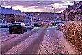
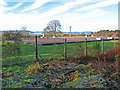
2
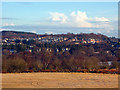
Peterculter village
A view of the village from Newmill Hill
Image: © Alan Findlay
Taken: 29 Nov 2008
0.10 miles
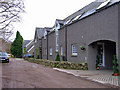
4
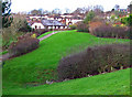
Houses at Bucklerburn, Peterculter
Built on farmland, the original farmhouse can be seen top right.
Image: © Alan Findlay
Taken: 8 Dec 2007
0.13 miles
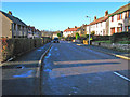
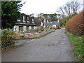
8
Bucklerburn Road
Ex farm road, now used to service new housing, looking east towards the junction with Culter House Road
Image: © Alan Findlay
Taken: 28 Oct 2007
0.15 miles
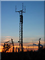
9
Communication mast on Ardbeck Hill Peterculter
Image: © Alan Findlay
Taken: 5 Nov 2007
0.15 miles
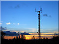
10
Communication mast on Ardbeck Hill Peterculter
Image: © Alan Findlay
Taken: 5 Nov 2007
0.15 miles