IMAGES TAKEN NEAR TO
Howie Lane, PETERCULTER, AB14 0LJ
Introduction
This page details the photographs taken nearby to Howie Lane, AB14 0LJ by members of the Geograph project.
The Geograph project started in 2005 with the aim of publishing, organising and preserving representative images for every square kilometre of Great Britain, Ireland and the Isle of Man.

There are currently over 7.5m images from over14,400 individuals and you can help contribute to the project by visiting https://www.geograph.org.uk
Image Map
Images are licensed for reuse under creativecommons.org/licenses/by-sa/2.0
Notes
- Clicking on the map will re-center to the selected point.
- The higher the marker number, the further away the image location is from the centre of the postcode.
Image Listing (85 Images Found)
Images are licensed for reuse under creativecommons.org/licenses/by-sa/2.0
Image
Details
Distance
1
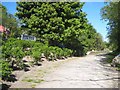
The old Culter Station on the Deeside Way
The railway which ran from Aberdeen to Banchory (and eventually on to Ballater) was opened in 1853 and closed in 1966; the station at Culter was the last on the line to be closed. The trackbed was restored in 2006 as the Deeside Way http://www.cyclegrampian.co.uk/trail/deeside.html , a very popular path for walkers which, with a few unfortunate breaks, runs for 25 Km from Duthie Park in Aberdeen to Banchory.
Image: © Oliver Dixon
Taken: 26 May 2008
0.02 miles
2
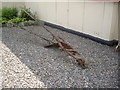
A 1-hp single-furrow plough
The farmer's friend, before the tractor-hauled multi-furrow age dawned. One of a number of old farming implements outside the Heritage Trust hall in Peterculter.
Image: © Stanley Howe
Taken: 14 Jun 2013
0.02 miles
3
Former 'Culter' railway station
On the old Deeside Railway from Aberdeen to Ballater.
Image: © Stanley Howe
Taken: 22 Apr 2010
0.02 miles
4
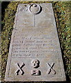
18th Century grave slab (II), Peterculter kirkyard
Dated 1733 for members of the Duncan family. Note the symbols of mortality: crossbones, skull, toppled hourglass, sexton's shovels. Compare a similar slab a few metres away: http://www.geograph.org.uk/photo/4847163 .
Image: © Bill Harrison
Taken: 28 Feb 2016
0.02 miles
5
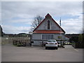
Heritage Hall, Peterculter
Peterculter. Formerly an 'Iron Kirkie' in Ballater, it was moved here in 1907 to be used as the church hall. Together with the adjacent Heritage Centre (ex St Peter's Church) it has been in the care of St Peter's Heritage Trust since 1999.
Image: © Stanley Howe
Taken: 22 Apr 2010
0.02 miles
6
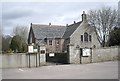
St Peter's Heritage Centre
Formerly St Peter's Church,Peterculter, dating from 1779 with a north wing added in 1895. It reopened as 'The Heritage Centre' on 2nd June 2001.
Image: © Stanley Howe
Taken: 22 Apr 2010
0.02 miles
7
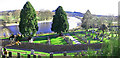
St Peters Church grave yard.
A view of St Peters church graveyard and the river Dee behind, photo taken from the Deeside Way.
Image: © Alan Findlay
Taken: 15 Mar 2007
0.02 miles
8
Culter Platform
The platform of the long disused, and disappeared, Culter Station on the Deeside Line.
Image: © Andrew Wood
Taken: 19 Mar 2009
0.02 miles
9
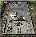
18th Century grave slab (I), Peterculter kirkyard
Dated 1733: the inscription to the deceased is illegible but the symbols of mortality (withered flowers, skull and crossbones, hourglass on its side, sexton's shovels) are still visible.
Image: © Bill Harrison
Taken: 28 Feb 2016
0.02 miles
10
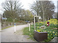
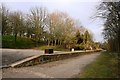
The start of Lovers Walk
From the carpark for the Heritage Centre in Peterculter; along the north bank of the River Dee to Pittengullies.
Image: © Stanley Howe
Taken: 14 Jun 2013
0.02 miles