IMAGES TAKEN NEAR TO
Beaconhill Road, MILLTIMBER, AB13 0JR
Introduction
This page details the photographs taken nearby to Beaconhill Road, AB13 0JR by members of the Geograph project.
The Geograph project started in 2005 with the aim of publishing, organising and preserving representative images for every square kilometre of Great Britain, Ireland and the Isle of Man.

There are currently over 7.5m images from over14,400 individuals and you can help contribute to the project by visiting https://www.geograph.org.uk
Image Map
Images are licensed for reuse under creativecommons.org/licenses/by-sa/2.0
Notes
- Clicking on the map will re-center to the selected point.
- The higher the marker number, the further away the image location is from the centre of the postcode.
Image Listing (6 Images Found)
Images are licensed for reuse under creativecommons.org/licenses/by-sa/2.0
Image
Details
Distance
1
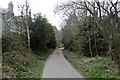
Deeside Railway trackbed, Milltimber
Now the Deeside Way, a cycle/foot path.
Image: © Richard Webb
Taken: 4 Apr 2017
0.04 miles
2
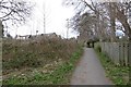
Path, Beaconhill
A path connecting the Deeside Way (rails to trails conversion of the Deeside Railway trackbed) with the A93 and Milltimber.
Image: © Richard Webb
Taken: 4 Apr 2017
0.05 miles
3
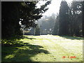
Tor-Na-Dee Hospital
This is a picture of a disused gate house for Tor-Na-Dee, taken from within the grounds, it has not served this purpose for many years.
Image: © George Wilson
Taken: 26 Apr 2005
0.17 miles
4
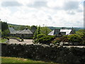
Houses near to Beaconhill
Different styles of housing with open countryside and the River Dee beyond.
Image: © Lizzie
Taken: 22 May 2005
0.18 miles
5
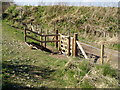
Gate built by Aberdeen Greenspace
Gate built by Aberdeen Greenspace to give access to the River Dee footpath
Image: © Ewen Rennie
Taken: 13 Apr 2009
0.24 miles
6
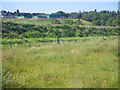
Horse operation above the River Dee floodplain
Photographer is standing in an expansive meadow that is effectively the floodplain of the River Dee. Very slightly to the west is a wetland dominated by juncus spp.
Image: © C Michael Hogan
Taken: 12 Jun 2011
0.25 miles