IMAGES TAKEN NEAR TO
Braehead Terrace, MILLTIMBER, AB13 0ED
Introduction
This page details the photographs taken nearby to Braehead Terrace, AB13 0ED by members of the Geograph project.
The Geograph project started in 2005 with the aim of publishing, organising and preserving representative images for every square kilometre of Great Britain, Ireland and the Isle of Man.

There are currently over 7.5m images from over14,400 individuals and you can help contribute to the project by visiting https://www.geograph.org.uk
Image Map
Images are licensed for reuse under creativecommons.org/licenses/by-sa/2.0
Notes
- Clicking on the map will re-center to the selected point.
- The higher the marker number, the further away the image location is from the centre of the postcode.
Image Listing (6 Images Found)
Images are licensed for reuse under creativecommons.org/licenses/by-sa/2.0
Image
Details
Distance
1
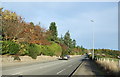
North Deeside Road (A93)
Heading east towards Aberdeen.
Image: © JThomas
Taken: 8 Nov 2013
0.15 miles
2
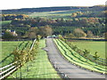
Farm track off North Deeside Road
Heading south.
Image: © JThomas
Taken: 8 Nov 2013
0.17 miles
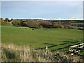
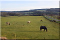
4
Countryside view from North Deeside Road
Photographer is near the fenceline along the south side of North Deeside Road.
Image: © C Michael Hogan
Taken: 25 Jun 2013
0.19 miles
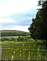
5
Urban farm
Milltimber Farm lies well within the boundary of Aberdeen City and would surely be worth a fortune to developers for houses but it is zoned as green belt for now (2019).
Image: © Bill Harrison
Taken: 1 Jan 2020
0.22 miles
6
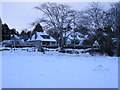
Houses on North Deeside Road Milltimber
Image: © Rod Richmond
Taken: 25 Dec 2004
0.24 miles