IMAGES TAKEN NEAR TO
Banchory Devenick, ABERDEEN, AB12 5YJ
Introduction
This page details the photographs taken nearby to AB12 5YJ by members of the Geograph project.
The Geograph project started in 2005 with the aim of publishing, organising and preserving representative images for every square kilometre of Great Britain, Ireland and the Isle of Man.

There are currently over 7.5m images from over14,400 individuals and you can help contribute to the project by visiting https://www.geograph.org.uk
Image Map
Images are licensed for reuse under creativecommons.org/licenses/by-sa/2.0
Notes
- Clicking on the map will re-center to the selected point.
- The higher the marker number, the further away the image location is from the centre of the postcode.
Image Listing (7 Images Found)
Images are licensed for reuse under creativecommons.org/licenses/by-sa/2.0
Image
Details
Distance
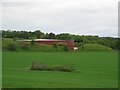
1
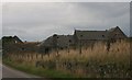
Steading under Blue Hill
Dilapidated farm steading under Blue Hill.
Image: © Andrew Wood
Taken: 1 Oct 2008
0.10 miles
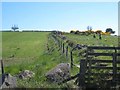
3
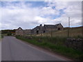
Ruined steadings, Hillside
SE of the summit of Blue Hill.
Image: © Stanley Howe
Taken: 6 May 2014
0.12 miles
6
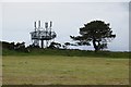
The path up Blue Hill
Telecommunications masts mark the top of Blue Hill. Although of modest elevation at only a little over 140m, Blue Hill gives spectacular views out to sea to the east and up to the Grampian Mountains to the west. In days of yore, Blue Hill was a popular Sunday excursion for Aberdonians.
Image: © Oliver Dixon
Taken: 25 May 2008
0.18 miles
7
Water storage reservoir tank
Shown as Wd Pp on some older maps
Image: © Lizzie
Taken: 5 Jun 2005
0.20 miles