IMAGES TAKEN NEAR TO
Covenanters Row, ABERDEEN, AB12 5QL
Introduction
This page details the photographs taken nearby to Covenanters Row, AB12 5QL by members of the Geograph project.
The Geograph project started in 2005 with the aim of publishing, organising and preserving representative images for every square kilometre of Great Britain, Ireland and the Isle of Man.

There are currently over 7.5m images from over14,400 individuals and you can help contribute to the project by visiting https://www.geograph.org.uk
Image Map
Images are licensed for reuse under creativecommons.org/licenses/by-sa/2.0
Notes
- Clicking on the map will re-center to the selected point.
- The higher the marker number, the further away the image location is from the centre of the postcode.
Image Listing (64 Images Found)
Images are licensed for reuse under creativecommons.org/licenses/by-sa/2.0
Image
Details
Distance
1
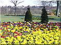
By Great Southern Road
Colourful floral displays alongside Aberdeen's major arterial roads help towards nearly annual Britain in Bloom awards. The background is the north bank of the Dee.
Image: © Colin Smith
Taken: 23 Mar 2008
0.06 miles
2
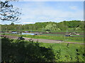
Goals Aberdeen
Looking westwards over the artificial pitches at Inverdee.
Image: © Scott Cormie
Taken: 21 May 2022
0.10 miles
3
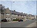
Faulds Gate, Kincorth
1930s Council houses, now mostly in private ownership.
Image: © Bill Harrison
Taken: 19 Apr 2014
0.11 miles

5
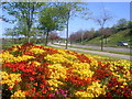
Floral Displays in Aberdeen
Aberdeen is renowned for winning many Britain in Bloom titles. This display is next to the main road to the south. The River Dee is nearby and King George VI bridge can be seen in the distance.
Image: © Richard Slessor
Taken: 9 May 2005
0.14 miles
6
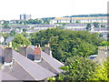
Kincorth from Ruthrieston
Kincorth was begun in the late 1930s as a garden suburb. Its streets follow the contours of Kincorth Hill and the housing scheme was a prize-winning one. The roofs in the foreground are in Ruthrieston Crescent.
Image: © Colin Smith
Taken: 6 Aug 2009
0.15 miles
7
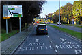
B9077, Great Southern Road, Ruthrieston
Image: © David Dixon
Taken: 24 Sep 2018
0.16 miles
8
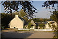
Suburban Carvery
The "Ghillie's Lair" at the southern end of the Brig o'Dee.
Image: © Bill Harrison
Taken: 15 Oct 2011
0.16 miles
9
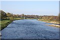
River Dee from the Bridge of Dee
Looking downstream towards the harbour and the sea from the old bridge over the River Dee. In the next square the banks are bright with daffodils, and in the distance only the 1960s concrete block of St Nicholas House rivals the kirk spires on the city centre skyline.
Image: © Anne Burgess
Taken: 19 Apr 2009
0.17 miles
10
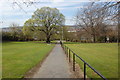
Path, Kincorth...
...connecting Kincorth Circle and Faulds Gate. The name Faulds Gate is said to derive from the Covenanters' Faulds, in memory of the Covenanting army who camped on Kincorth hill before the Battle of Bridge of Dee on 19th June 1639.
Image: © Bill Harrison
Taken: 19 Apr 2014
0.17 miles