IMAGES TAKEN NEAR TO
Caiesdykes Crescent, ABERDEEN, AB12 5JL
Introduction
This page details the photographs taken nearby to Caiesdykes Crescent, AB12 5JL by members of the Geograph project.
The Geograph project started in 2005 with the aim of publishing, organising and preserving representative images for every square kilometre of Great Britain, Ireland and the Isle of Man.

There are currently over 7.5m images from over14,400 individuals and you can help contribute to the project by visiting https://www.geograph.org.uk
Image Map
Images are licensed for reuse under creativecommons.org/licenses/by-sa/2.0
Notes
- Clicking on the map will re-center to the selected point.
- The higher the marker number, the further away the image location is from the centre of the postcode.
Image Listing (23 Images Found)
Images are licensed for reuse under creativecommons.org/licenses/by-sa/2.0
Image
Details
Distance
1
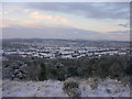
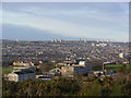
Snow Covered Roof Tops of Aberdeen
This wintry view of Aberdeen was taken from Kincorth Hill.
Image: © Richard Slessor
Taken: 29 Dec 2005
0.09 miles
3
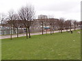
Kincorth Swimming Pool
Attached to Kincorth Academy, but also for public use. http://aberdeencity.gov.uk/xsl_SportsVenueDetail.asp?fid=25
Image: © Bill Harrison
Taken: 15 Oct 2011
0.14 miles
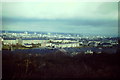
5
Aberdeen from Kincorth Hill
Viewpoint at 105m from the surprisingly lovely Kincorth Hill. Aberdeen in all its characteristic grey-tan glory
Image: © Peter Robinson
Taken: 30 Jan 2012
0.15 miles
6
The "Gramps", aka Kincorth Hill.
The "Gramps" are the tail end of the Mounth, the Grampian Mountains as they reach the North Sea. The area is a country park with gorse bushes, one or two old quarries, and fine views over Aberdeen.
Image: © Colin Smith
Taken: Unknown
0.15 miles
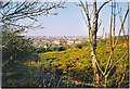
7
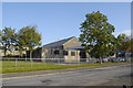
Kincorth from "The Gramps"
View from Kincorth Hill, over Kincorth Academy, to Aberdeen city centre in the distance.
Image: © Colin Smith
Taken: 1 Mar 1983
0.15 miles
9
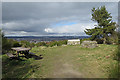
Kincorth Hill Viewpoint
The view indicator has faded to the point where any information it might have contained has become completely illegible. The cairn on the right has a Image] of Kincorth Hill, though there doesn't seem to be anything explanatory on it. The view would have been much better in bright sunshine; it was not worth photographing under the grey sky.
Image: © Anne Burgess
Taken: 20 Mar 2020
0.21 miles
10
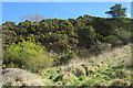
Quarry Face
Lurking beneath the overhanging whins are a few square metres of exposure of a vertical face of pinkish granite that must be a relic of quarrying activity.
Image: © Anne Burgess
Taken: 20 Mar 2020
0.21 miles