IMAGES TAKEN NEAR TO
Maryculter, ABERDEEN, AB12 5GN
Introduction
This page details the photographs taken nearby to AB12 5GN by members of the Geograph project.
The Geograph project started in 2005 with the aim of publishing, organising and preserving representative images for every square kilometre of Great Britain, Ireland and the Isle of Man.

There are currently over 7.5m images from over14,400 individuals and you can help contribute to the project by visiting https://www.geograph.org.uk
Image Map
Images are licensed for reuse under creativecommons.org/licenses/by-sa/2.0
Notes
- Clicking on the map will re-center to the selected point.
- The higher the marker number, the further away the image location is from the centre of the postcode.
Image Listing (5 Images Found)
Images are licensed for reuse under creativecommons.org/licenses/by-sa/2.0
Image
Details
Distance
1
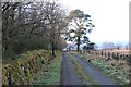
Access road to Mains of Altries
The drystone dyke is well covered by moss due to its northern aspect and the tree shade.
Image: © Alan Reid
Taken: 17 Dec 2019
0.12 miles
2
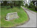
Drive way to Mains of Altries
The engraved stone marking the entrance to the Mains of Altries.
Image: © George Wilson
Taken: 21 Jul 2007
0.13 miles
3
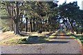
Pine wood at the entry to Mains of Altries
Image: © Alan Reid
Taken: 17 Dec 2019
0.13 miles
4
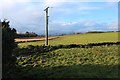
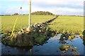
Drystone field boundaries at Mains of Altries
Image: © Alan Reid
Taken: 17 Dec 2019
0.22 miles