IMAGES TAKEN NEAR TO
Well Brae, ABERDEEN, AB12 4WX
Introduction
This page details the photographs taken nearby to Well Brae, AB12 4WX by members of the Geograph project.
The Geograph project started in 2005 with the aim of publishing, organising and preserving representative images for every square kilometre of Great Britain, Ireland and the Isle of Man.

There are currently over 7.5m images from over14,400 individuals and you can help contribute to the project by visiting https://www.geograph.org.uk
Image Map
Images are licensed for reuse under creativecommons.org/licenses/by-sa/2.0
Notes
- Clicking on the map will re-center to the selected point.
- The higher the marker number, the further away the image location is from the centre of the postcode.
Image Listing (4 Images Found)
Images are licensed for reuse under creativecommons.org/licenses/by-sa/2.0
Image
Details
Distance
1
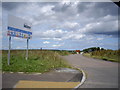
Access to Development Site, Hillside
Stewart Milne (contractor) sign.
Image: © Stanley Howe
Taken: 20 Jul 2009
0.01 miles
2
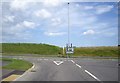
New T-Junction at Hillside
Left to Aberdeen; right to Portlethen.
Image: © Stanley Howe
Taken: 20 Jul 2009
0.04 miles
3
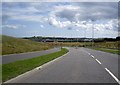
New access road to A90 underpass, Portlethen
Image: © Stanley Howe
Taken: 20 Jul 2009
0.12 miles
4
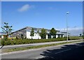
Hillside Primary School, Portlethen
One of Aberdeenshire's new-build primary schools dating from 2017 catering for ever-expanding commuter towns like Portlethen. School roll (2021-22): 484 children + 74 in the nursery. Compare Kintore Primary School: https://www.geograph.org.uk/photo/5439549 .
Image: © Bill Harrison
Taken: 3 Jun 2022
0.23 miles