IMAGES TAKEN NEAR TO
Haremoss Drive, ABERDEEN, AB12 4UX
Introduction
This page details the photographs taken nearby to Haremoss Drive, AB12 4UX by members of the Geograph project.
The Geograph project started in 2005 with the aim of publishing, organising and preserving representative images for every square kilometre of Great Britain, Ireland and the Isle of Man.

There are currently over 7.5m images from over14,400 individuals and you can help contribute to the project by visiting https://www.geograph.org.uk
Image Map
Images are licensed for reuse under creativecommons.org/licenses/by-sa/2.0
Notes
- Clicking on the map will re-center to the selected point.
- The higher the marker number, the further away the image location is from the centre of the postcode.
Image Listing (5 Images Found)
Images are licensed for reuse under creativecommons.org/licenses/by-sa/2.0
Image
Details
Distance
1
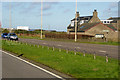
Edge of the countryside...
Cows coexist with a business park on the edge of Portlethen. Note the bank of coastal for or 'haar' in the background.
Image: © Bill Harrison
Taken: 3 Jun 2022
0.19 miles
2
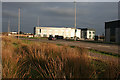
Business Park
These blocks are on the edge of a fairly small business park on the outskirts of Portlethen, west of the A90 dual carriageway. It was unusually quiet today, as most businesses were still on their New Year holiday.
Image: © Anne Burgess
Taken: 2 Jan 2019
0.22 miles
3
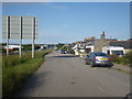
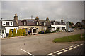
Island residential street adjacent to dual carriageway
This odd street has no access other than directly to the dual carriageway. Thus the sound levels are quite high here, as front yards face the A90.
Image: © C Michael Hogan
Taken: 9 Jun 2011
0.23 miles