IMAGES TAKEN NEAR TO
Portlethen, ABERDEEN, AB12 4SB
Introduction
This page details the photographs taken nearby to AB12 4SB by members of the Geograph project.
The Geograph project started in 2005 with the aim of publishing, organising and preserving representative images for every square kilometre of Great Britain, Ireland and the Isle of Man.

There are currently over 7.5m images from over14,400 individuals and you can help contribute to the project by visiting https://www.geograph.org.uk
Image Map
Images are licensed for reuse under creativecommons.org/licenses/by-sa/2.0
Notes
- Clicking on the map will re-center to the selected point.
- The higher the marker number, the further away the image location is from the centre of the postcode.
Image Listing (4 Images Found)
Images are licensed for reuse under creativecommons.org/licenses/by-sa/2.0
Image
Details
Distance
1
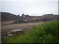
Strange coastal industrial land use
Photographer is standing near a large scale industrial gravel staging area; moreover, this type of land use so near the beautiful rugged coastline is a very strange council decision.
Image: © C Michael Hogan
Taken: 11 Jun 2011
0.15 miles
2
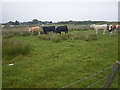
Cows grazing not far from the coastline
This pasture is very moist and exhibits a high occurrence of Juncus species.
Image: © C Michael Hogan
Taken: 11 Jun 2011
0.22 miles
3
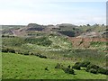
Gravel pit, Finedon
Extensive quarry workings beside the railway.
Image: © Richard Webb
Taken: 3 Aug 2011
0.23 miles
4
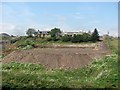
Mains of Cairnrobin
Derelict farm with a nearby quarry.
Image: © Richard Webb
Taken: 3 Aug 2011
0.25 miles