IMAGES TAKEN NEAR TO
Argyll Place, ABERDEEN, AB12 4QZ
Introduction
This page details the photographs taken nearby to Argyll Place, AB12 4QZ by members of the Geograph project.
The Geograph project started in 2005 with the aim of publishing, organising and preserving representative images for every square kilometre of Great Britain, Ireland and the Isle of Man.

There are currently over 7.5m images from over14,400 individuals and you can help contribute to the project by visiting https://www.geograph.org.uk
Image Map
Images are licensed for reuse under creativecommons.org/licenses/by-sa/2.0
Notes
- Clicking on the map will re-center to the selected point.
- The higher the marker number, the further away the image location is from the centre of the postcode.
Image Listing (16 Images Found)
Images are licensed for reuse under creativecommons.org/licenses/by-sa/2.0
Image
Details
Distance
1
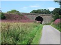
Railway bridge, Portlethen
A massive bridge on a long embankment. The railway crosses Thistle Drive and route 1 of the National Cycle Network.
Image: © Richard Webb
Taken: 3 Aug 2011
0.06 miles
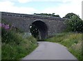
3
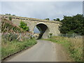
Miller's Bridge
Miller's Bridge carrying the East Coast Railway Line over the road on the edge of Portlethen near the Mill of Findon.
Image: © Scott Cormie
Taken: 17 Sep 2022
0.06 miles
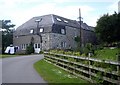
5
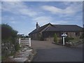
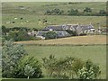
The Steading, Mill of Findon
From the west.
Image: © Stanley Howe
Taken: 20 Jul 2009
0.14 miles
8
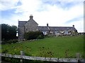
The Steading, Mill of Findon
From the south.
Image: © Stanley Howe
Taken: 20 Jul 2009
0.15 miles
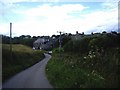
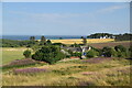
9
View towards Mill of Findon
From Portlethen churchyard.
Image: © Stanley Howe
Taken: 20 Jul 2009
0.16 miles
10
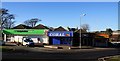
Shops in Portlethen
Small group of shops in Portlethen.
Image: © Colin Kinnear
Taken: 10 Feb 2011
0.17 miles