IMAGES TAKEN NEAR TO
Cairnrobin Way, ABERDEEN, AB12 4NJ
Introduction
This page details the photographs taken nearby to Cairnrobin Way, AB12 4NJ by members of the Geograph project.
The Geograph project started in 2005 with the aim of publishing, organising and preserving representative images for every square kilometre of Great Britain, Ireland and the Isle of Man.

There are currently over 7.5m images from over14,400 individuals and you can help contribute to the project by visiting https://www.geograph.org.uk
Image Map
Images are licensed for reuse under creativecommons.org/licenses/by-sa/2.0
Notes
- Clicking on the map will re-center to the selected point.
- The higher the marker number, the further away the image location is from the centre of the postcode.
Image Listing (13 Images Found)
Images are licensed for reuse under creativecommons.org/licenses/by-sa/2.0
Image
Details
Distance
1
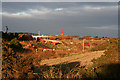
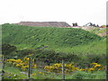
Post-industrial Scene
I am not entirely sure what this is. It's on the west side of the railway near Findon, and it might be the southern end of gravel workings. Or it might be some other industrial activity.
Image: © Anne Burgess
Taken: 2 Jan 2019
0.12 miles
2
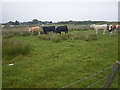
Cows grazing not far from the coastline
This pasture is very moist and exhibits a high occurrence of Juncus species.
Image: © C Michael Hogan
Taken: 11 Jun 2011
0.18 miles
3
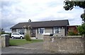
Road to Marywell from A90
Image: © Dominic Dawn Harry and Jacob Paterson
Taken: 24 Mar 2006
0.20 miles
4
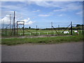
Football ground by Hill Crest railway cutting
Commercial Sponsorship boards on display. Home to Parkvale FC of the Northern Region, Scottish Junior FA.
Image: © Stanley Howe
Taken: 20 Jul 2009
0.21 miles
5
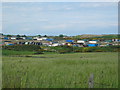
Parked lorries and containers
An area of containers and lorries parked close to Roadside of Findon.
Image: © Lizzie
Taken: 18 Jun 2005
0.22 miles
6
Gravel pit
Gravel pit shown close to Mairns of Cairnrobin
Image: © Lizzie
Taken: 18 Jun 2005
0.22 miles
7
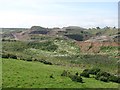
Gravel pit, Finedon
Extensive quarry workings beside the railway.
Image: © Richard Webb
Taken: 3 Aug 2011
0.22 miles
8

East Coast main line (N)
From the road bridge by Hill Crest. There is a sports pavilion and playing fields just to the left (west) of the railway cutting.
Image: © Stanley Howe
Taken: 20 Jul 2009
0.23 miles
9
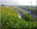
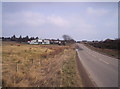
Looking south on the A90 from a hammerhead above the frontage road
The photo position is from a perch on a dead end residential street on the east side of A90.
Image: © C Michael Hogan
Taken: 5 Jun 2010
0.24 miles