IMAGES TAKEN NEAR TO
Boswell Road, ABERDEEN, AB12 4BA
Introduction
This page details the photographs taken nearby to Boswell Road, AB12 4BA by members of the Geograph project.
The Geograph project started in 2005 with the aim of publishing, organising and preserving representative images for every square kilometre of Great Britain, Ireland and the Isle of Man.

There are currently over 7.5m images from over14,400 individuals and you can help contribute to the project by visiting https://www.geograph.org.uk
Image Map
Images are licensed for reuse under creativecommons.org/licenses/by-sa/2.0
Notes
- Clicking on the map will re-center to the selected point.
- The higher the marker number, the further away the image location is from the centre of the postcode.
Image Listing (7 Images Found)
Images are licensed for reuse under creativecommons.org/licenses/by-sa/2.0
Image
Details
Distance
2
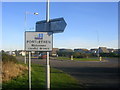
Portlethen
Until the 1970s the only settlement at Portlethen was the old fishing village at Image Since then it has grown into a dormitory settlement, home to around 7000 people.
Image: © Richard Slessor
Taken: 30 Jan 2006
0.19 miles
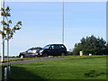
5
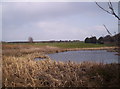
A Small Pond and 13th Green
A small pond at the southern edge of Portlethen golf course.
Image: © Dominic Dawn Harry and Jacob Paterson
Taken: 24 Mar 2006
0.22 miles
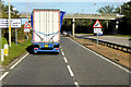
6
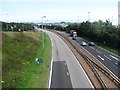
A90, Portlethen
The road linking Aberdeen with the South passes the new industrial community of Portlethen.
Image: © Richard Webb
Taken: 3 Aug 2011
0.23 miles
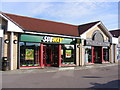
7
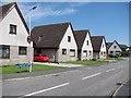
Cairnwell Drive
Like almost all of Portlethen, new.
Image: © Richard Webb
Taken: 3 Aug 2011
0.25 miles