IMAGES TAKEN NEAR TO
Newlands Lane South, ABERDEEN, AB12 3FS
Introduction
This page details the photographs taken nearby to Newlands Lane South, AB12 3FS by members of the Geograph project.
The Geograph project started in 2005 with the aim of publishing, organising and preserving representative images for every square kilometre of Great Britain, Ireland and the Isle of Man.

There are currently over 7.5m images from over14,400 individuals and you can help contribute to the project by visiting https://www.geograph.org.uk
Image Map
Images are licensed for reuse under creativecommons.org/licenses/by-sa/2.0
Notes
- Clicking on the map will re-center to the selected point.
- The higher the marker number, the further away the image location is from the centre of the postcode.
Image Listing (10 Images Found)
Images are licensed for reuse under creativecommons.org/licenses/by-sa/2.0
Image
Details
Distance
2
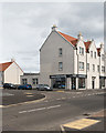
Haar Rock Coffee
A local coffee shop in a new development.
Image: © Nigel Corby
Taken: 4 Apr 2017
0.11 miles
4
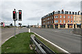
Mixed residential and business development
A recent mixed residential and business development at the junction of Wellington Road and Charleston Road North. Sainsbury's occupies the ground floor on the corner.
Image: © Nigel Corby
Taken: 4 Apr 2017
0.13 miles
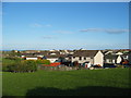
5
Loirston Court in Cove Bay
Modern housing in Cove Bay on the outskirts of Aberdeen.
Image: © Colin Kinnear
Taken: 19 Jan 2011
0.15 miles
6
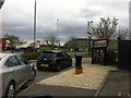
Drive Thru
At Burger King at Wellington Circle roundabout, Altens.
Image: © Darrin Antrobus
Taken: 21 May 2013
0.18 miles
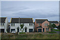
8
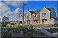
Whitehills Housing Estate
This new development has been built in the last year or two on the fringe of Charlestown.
Image: © Anne Burgess
Taken: 20 Mar 2020
0.23 miles
9
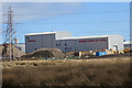
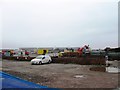
Balmoral Subsea Test Centre
I gather that the building contains pressurised tanks up to 15 metres deep for testing deep sea equipment at pressures up to 700 bar, or 691 atmospheres. The tanks were excavated deep down into the granite bedrock. See https://www.balmoraloffshore.com/discover/balmoral-subsea-test-centre for more fascinating facts.
Image: © Anne Burgess
Taken: 20 Mar 2020
0.25 miles
10
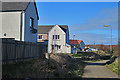
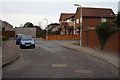
South Loirston Road
South Loirston Road was until a couple of decades ago a tiny minor road meandering across farmland. It now passes between large housing estates, though fortunately the planners have had the sense not to use it for vehicular access.
Image: © Anne Burgess
Taken: 20 Mar 2020
0.25 miles