IMAGES TAKEN NEAR TO
Miller Street, ABERDEEN, AB11 5AN
Introduction
This page details the photographs taken nearby to Miller Street, AB11 5AN by members of the Geograph project.
The Geograph project started in 2005 with the aim of publishing, organising and preserving representative images for every square kilometre of Great Britain, Ireland and the Isle of Man.

There are currently over 7.5m images from over14,400 individuals and you can help contribute to the project by visiting https://www.geograph.org.uk
Image Map
Images are licensed for reuse under creativecommons.org/licenses/by-sa/2.0
Notes
- Clicking on the map will re-center to the selected point.
- The higher the marker number, the further away the image location is from the centre of the postcode.
Image Listing (170 Images Found)
Images are licensed for reuse under creativecommons.org/licenses/by-sa/2.0
Image
Details
Distance
1
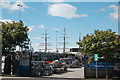
Storage yard, Miller Street, Aberdeen
The tall ship in the background is, I believe, the Sea Cloud II, a luxury cruise ship built as recently as 1999: https://en.wikipedia.org/wiki/Sea_Cloud_II .
Image: © Bill Harrison
Taken: 13 Aug 2016
0.04 miles
2
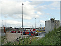
Cable drums at Intermoor, Miller Street, Aberdeen
One of many industries in this area supporting the offshore sector.
Image: © Stephen Craven
Taken: 1 Jul 2019
0.04 miles
3
Warehouse of the Shore Porters' Society, Baltic Place, Aberdeen
The Shore Porters' Society was founded in 1498 as a cooperative of dock workers at Aberdeen Harbour. In more recent centuries, it has developed into a removal and general transport company. One of their famous blue and red lorries is parked to the right. For more history, see:
http://www.shoreporters.com/shore-porters-history.php
Image: © Bill Harrison
Taken: 27 Nov 2011
0.06 miles
4
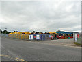
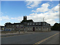
SCARF, Cotton Street, Aberdeen
SCARF is a social enterprise supporting energy efficiency and sustainable living, but I'm not sure what, if anything, SCARF stands for: http://www.scarf.org.uk/about-us/ . Note the solar panels on the roof.
Image: © Bill Harrison
Taken: 13 Aug 2016
0.07 miles
5
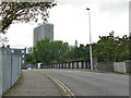
Castle Street bridge, Aberdeen
The bridge crosses the throat of what was the Waterloo goods station, of which only a few sidings remain Image Comparison with the 1902 map shows it has been rebuilt on a new alignment since then, but before 1955.
Image: © Stephen Craven
Taken: 1 Jul 2019
0.07 miles
6
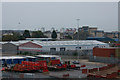
Remains of Waterloo goods station, Aberdeen
There are still a handful of sidings here, the one on the right serving Greco Developments Image, and those on the left now being known as "Waterloo Multi-Modal Terminal" for trans-shipment of containers.
Image: © Stephen Craven
Taken: 1 Jul 2019
0.07 miles
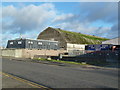
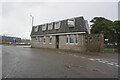
7
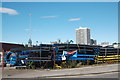
Pipe storage yard
These no doubt have some sort of offshore application. The three towers in the distance are, left to right, the Town House (with scaffolding), the Salvation Army Citadel and Mitchell Tower at Marischal College.
Image: © Bill Harrison
Taken: 13 Aug 2016
0.08 miles
8
Rail terminal on the dockside at Aberdeen
Little used by trains these days I suspect.
Image: © Mike Pennington
Taken: 20 Oct 2011
0.08 miles
9
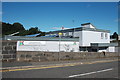
The Shore Porters Society, Baltic Place, Aberdeen
The organisation sounds as if they unload ships. Maybe they once did, but from their website it seems they are now a removals and storage business. See Image for a view from St Clement's Street (the church of the same name can be seen in the background).
Image: © Stephen Craven
Taken: 1 Jul 2019
0.09 miles
10
Shore Porters Society, Miller Street, Aberdeen
Image: © Ian S
Taken: 4 Oct 2022
0.10 miles