Two Old Boundary Markers beside Lansdown Road, Bath
Introduction
The photograph on this page of Two Old Boundary Markers beside Lansdown Road, Bath by Roadside Relics as part of the Geograph project.
The Geograph project started in 2005 with the aim of publishing, organising and preserving representative images for every square kilometre of Great Britain, Ireland and the Isle of Man.

There are currently over 7.5m images from over 14,400 individuals and you can help contribute to the project by visiting https://www.geograph.org.uk
Two Old Boundary Markers beside Lansdown Road, Bath
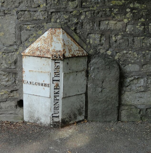
Image: © Roadside Relics Taken: 5 Jun 2024
Two boundary markers set in the pavement and against the stone boundary wall of Innisfree, formerly Mitford House, on the northeast side of Lansdown Road, Bath. See also https://www.geograph.org.uk/photo/7782357. On the left is a Turnpike Parish Boundary Marker. It is marked CARLCOMBE on the left face, WESTON on the right face, separated by (BA)TH TURNPIKE TRUST vertically with the date 1835 above. Milestone Society National ID: SO_BAWK00pb On the right is a Parish Boundary Marker inscribed W P for Weston Parish. Milestone Society National ID: SO_BAWK03pb
Images are licensed for reuse under creativecommons.org/licenses/by-sa/2.0
Image Location
Latitude
51.39503
Longitude
-2.365461