Bury St Edmunds houses [100]
Introduction
The photograph on this page of Bury St Edmunds houses [100] by Michael Dibb as part of the Geograph project.
The Geograph project started in 2005 with the aim of publishing, organising and preserving representative images for every square kilometre of Great Britain, Ireland and the Isle of Man.

There are currently over 7.5m images from over 14,400 individuals and you can help contribute to the project by visiting https://www.geograph.org.uk
Bury St Edmunds houses [100]
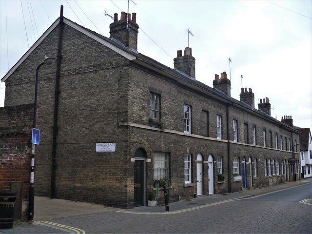
Image: © Michael Dibb Taken: 12 Sep 2020
This terrace of small houses, numbers 21 to 30 Whiting Street originally contained 10 houses, now 8. Numbers 25 and 26, and numbers 27 and 28 have each been made into a single house and the former doorways of numbers 26 and 27 are now windows. Built circa 1840 with white brick fronts and red brick with flint rears. As with many buildings in Bury St Edmunds, the cellars are older than the houses above. Listed, grade II, with details at: https://historicengland.org.uk/listing/the-list/list-entry/1096760 Whiting Street is one of the north-south streets laid out by Abbot Baldwin in the 12th century and has buildings from the early medieval to the late 20th century. The street is divided by Churchgate Street at its midpoint and the character is mainly residential to the southern part with a mixture of residential with retail and commercial uses to the northern part. Bury St Edmunds is a market town which is the cultural and retail centre for West Suffolk and is known for brewing (Greene King) and sugar (British Sugar). There is scattered evidence of earlier activity but essentially Bury St Edmunds began as one of the royal boroughs of the Saxons and a monastery was founded which became the burial place of King Edmund. A new Benedictine abbey was built in 1020 which became rich and powerful and the town was laid out on a grid pattern by Abbot Baldwin. After the dissolution the abbey became ruinous. A new church, later the cathedral, was begun in the early 16th century.
Images are licensed for reuse under creativecommons.org/licenses/by-sa/2.0
Image Location
Latitude
52.241711
Longitude
0.713304