Old Milestone by the A58, Wetherby Road, Leeds
Introduction
The photograph on this page of Old Milestone by the A58, Wetherby Road, Leeds by Milestone Society as part of the Geograph project.
The Geograph project started in 2005 with the aim of publishing, organising and preserving representative images for every square kilometre of Great Britain, Ireland and the Isle of Man.

There are currently over 7.5m images from over 14,400 individuals and you can help contribute to the project by visiting https://www.geograph.org.uk
Old Milestone by the A58, Wetherby Road, Leeds
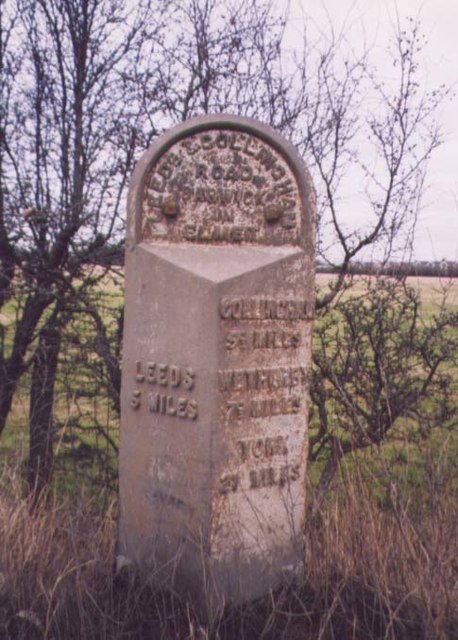
Image: © Milestone Society Taken: Unknown
Milestone by the A58, in parish of Barwick in Elmet and Scholes (Leeds District), Wetherby Road, North of Wellington Hill and traffic lights at Redhall Lane, on verge near traffic lights sign, and telegraph pole TP111. Inscription reads:- : LEEDS / 5 MILES : : LEEDS & COLLINGHAM / ROAD / BARWICK / IN / ELMET : : COLLINGHAM / 5½ MILES / WETHERBY / 7½ MILES / YORK / 27 MILES : Milestone Society National ID: YW_LECM05
Images are licensed for reuse under creativecommons.org/licenses/by-sa/2.0
Image Location


Leaflet Map data © OpenStreetMap
Latitude
53.842206
Longitude
-1.468206