Old Milestone, Former A438, Clyro village
Introduction
The photograph on this page of Old Milestone, Former A438, Clyro village by Milestone Society as part of the Geograph project.
The Geograph project started in 2005 with the aim of publishing, organising and preserving representative images for every square kilometre of Great Britain, Ireland and the Isle of Man.

There are currently over 7.5m images from over 14,400 individuals and you can help contribute to the project by visiting https://www.geograph.org.uk
Old Milestone, Former A438, Clyro village
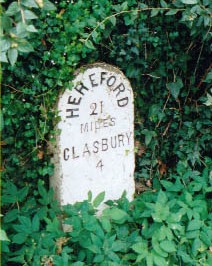
Image: © Milestone Society Taken: Unknown
The milestone is located opposite the entrance to the Baskerville Arms, set against the stone boundary wall to Ashbrook House, on the south east side of road. Community of Clyro (Powys District). Stone post, erected by the Radnorshire Turnpike Trust in the late 18th / early 19th century. See also https://www.geograph.org.uk/photo/6102856 Inscription reads:- HEREFORD / 21 / MILES / GLASBURY / 4 Cadw Grade II listed , reference number: 8744 https://cadwpublic-api.azurewebsites.net/reports/listedbuilding/FullReport?lang=&id=8744 Milestone Society National ID: RAD_HFGY21
Images are licensed for reuse under creativecommons.org/licenses/by-sa/2.0
Image Location
Latitude
52.087584
Longitude
-3.147867