Hall beside John Street
Introduction
The photograph on this page of Hall beside John Street by Lairich Rig as part of the Geograph project.
The Geograph project started in 2005 with the aim of publishing, organising and preserving representative images for every square kilometre of Great Britain, Ireland and the Isle of Man.

There are currently over 7.5m images from over 14,400 individuals and you can help contribute to the project by visiting https://www.geograph.org.uk
Hall beside John Street
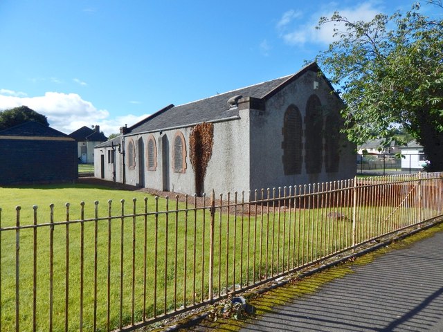
Image: © Lairich Rig Taken: 29 Aug 2016
The hall appears (labelled simply "Hall") on the 1936/37 revision of the OS map, but was not present on the 1914 revision. It is now, as it was just before the Second World War, just to the north of a bowling green (Renton Veteran's Bowling Club). To me, it has the look of a church hall. It was presumably associated with Image: in the late Jim Murphy's very useful book "Renton Between the Wars" (2007), a photograph on page 46 includes this hall, and the accompanying caption states that "the local Parish Church authorities have kindly allowed the veterans the use of the adjoining hall for carpet bowls and social functions". The white building at the far right was, several decades ago, a clinic, and perhaps still is. A short lane behind (i.e., just south of) that building leads to the main road (Lennox Street). The lane is not named on maps, but in a diagram in the book just cited, it is labelled Scot's Avenue, which was perhaps a nickname of long standing. I suspect (but cannot confirm) that the name is connected to the Scotts who once lived in Dalquhurn Cottage: see Image The lane itself preserves the line of a road that used to lead past Dalquhurn Cottage (as reference to the first-edition OS map, surveyed in 1860, will reveal), and which long pre-dates the nearby present-day John Street.
Images are licensed for reuse under creativecommons.org/licenses/by-sa/2.0
Image Location
Latitude
55.966644
Longitude
-4.582347