The southern end of the Jewish section at the Belfast City Cemetery
Introduction
The photograph on this page of The southern end of the Jewish section at the Belfast City Cemetery by Eric Jones as part of the Geograph project.
The Geograph project started in 2005 with the aim of publishing, organising and preserving representative images for every square kilometre of Great Britain, Ireland and the Isle of Man.

There are currently over 7.5m images from over 14,400 individuals and you can help contribute to the project by visiting https://www.geograph.org.uk
The southern end of the Jewish section at the Belfast City Cemetery
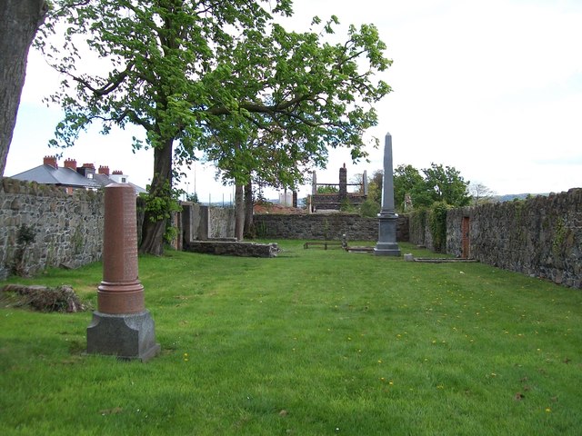
Image: © Eric Jones Taken: 27 Apr 2012
This image shows a number of interesting feature. The obelisk on the right marks the resting place of the Hamburg-born Daniel Joseph Jaffe (1809-1874). A leading Belfast linen merchant, he died at Nice and was the first to be buried in this newly acquired Jewish burial ground. Daniel Jaffe was the father of Otto Jaffe, Lord Mayor of Belfast. The ruined building on the left, of which only the foundations remain, was a mortuary chapel. The red marble memorial in the foreground, erected in 1931 by the Belfast Chevra Kadisha, commemorates those buried in the Jewish "poor ground" - the "empty" green area. Under conditions laid down for the establishment of a Jewish cemetery no headstones were allowed for those who were buried in the poor ground. The outline of the graves can be seen in the satellite image on Google Maps.
Images are licensed for reuse under creativecommons.org/licenses/by-sa/2.0
Image Location
Latitude
54.590462
Longitude
-5.976063