Former factory buildings of W T Henley?s Cable Works
Introduction
The photograph on this page of Former factory buildings of W T Henley?s Cable Works by Marathon as part of the Geograph project.
The Geograph project started in 2005 with the aim of publishing, organising and preserving representative images for every square kilometre of Great Britain, Ireland and the Isle of Man.

There are currently over 7.5m images from over 14,400 individuals and you can help contribute to the project by visiting https://www.geograph.org.uk
Former factory buildings of W T Henley?s Cable Works
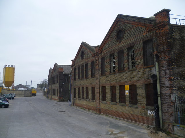
Image: © Marathon Taken: 5 Apr 2012
No part of Gravesend is more run down at present than the area along by the river to the west of the centre, in the area known as Rosherville. Rosherville Gardens were laid out in 1837 in one of the disused chalk pits next to Crete Hall Road, and covered an area of 17 acres. Their full title was the 'Kent Zoological and Botanical Gardens Institution’. In the Victorian period they became a favourite destination for thousands of Londoners, many travelling by paddle steamer down the River Thames to disembark at the pier built to service the gardens. In the 1850s up to 20,000 visitors passed through the turnstiles in a week. By 1880 the gardens had reached the peak of their popularity and in 1901 they were closed. In 1924 five acres of the land was sold to W T Henley’s Cable Works, which had occupied the land between Rosherville Gardens and the Thames since 1906. In 1939 Henley’s bought the rest of the land and the site was completely cleared. Most of Henley's Works has in turn been cleared, but the former offices built in the 1930s in art deco style remain as do some of the former factory buildings. The factory buildings seen here along The Shore are now empty and vandalised. They probably date from 1906 when Henley's needed a bigger site and moved their cable works from North Woolwich to here at Rosherville. The area will soon be redeveloped again as part of the Thames Gateway but whether these buildings can be saved and put to use again is debatable.
Images are licensed for reuse under creativecommons.org/licenses/by-sa/2.0
Image Location
Latitude
51.445612
Longitude
0.351795