Junction of Fox Hill, Tudor Road and Lansdowne Place, Upper Norwood
Introduction
The photograph on this page of Junction of Fox Hill, Tudor Road and Lansdowne Place, Upper Norwood by Christopher Hilton as part of the Geograph project.
The Geograph project started in 2005 with the aim of publishing, organising and preserving representative images for every square kilometre of Great Britain, Ireland and the Isle of Man.

There are currently over 7.5m images from over 14,400 individuals and you can help contribute to the project by visiting https://www.geograph.org.uk
Junction of Fox Hill, Tudor Road and Lansdowne Place, Upper Norwood
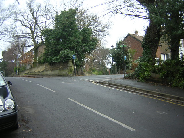
Image: © Christopher Hilton Taken: 1 Jan 2011
Fox Hill comes in from the bottom right of the photograph and exits left. At the top of the climb, Lansdowne Place goes away in the direction the photographer is facing, whilst Tudor Road comes in from the right behind the trees. A direction marker for the Capital Ring long-distance path can be seen at the top of the climb, directing walkers along Tudor Road and the further portion of Fox Hill. The nearer section of Fox Hill carries the boundary between the London Boroughs of Bromley and Croydon (previously between the counties of Kent and Surrey respectively). Unusually, the boundary runs not down the middle of the road, but along the property frontages on the far side of the road. The boundary continues up Lansdowne Place and a metal boundary marker Image can be seen to the left of the green Capital Ring sign. At the time that the metal boundary post shown here was erected, the land on the Kent side of the boundary (in this photograph, the right side), later the Urban District of Penge, was a detached portion of the parish of Battersea, whilst that in which the photographer is standing was part of the parish of Croydon.
Images are licensed for reuse under creativecommons.org/licenses/by-sa/2.0
Image Location
Latitude
51.41634
Longitude
-0.080019