Teasels growing beside the River Little Ouse
Introduction
The photograph on this page of Teasels growing beside the River Little Ouse by Evelyn Simak as part of the Geograph project.
The Geograph project started in 2005 with the aim of publishing, organising and preserving representative images for every square kilometre of Great Britain, Ireland and the Isle of Man.

There are currently over 7.5m images from over 14,400 individuals and you can help contribute to the project by visiting https://www.geograph.org.uk
Teasels growing beside the River Little Ouse
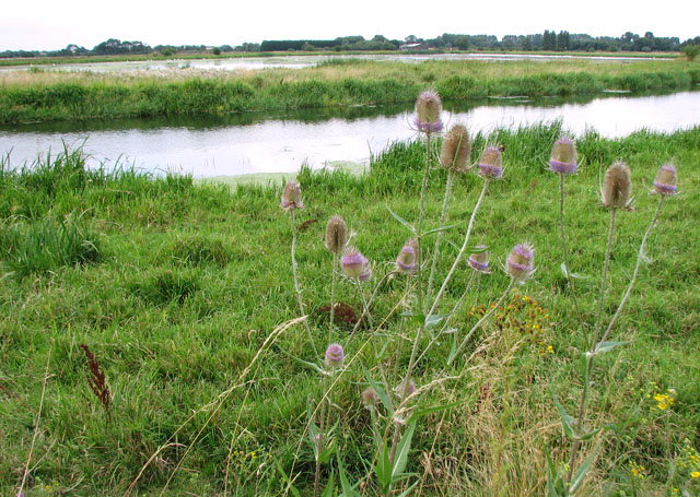
Image: © Evelyn Simak Taken: 5 Aug 2010
View across the River Little Ouse and the washland beyond, taken from the Hereward Way. This section of the long distance footpath follows the course of the River Little Ouse as it meanders through Lakenheath Fen nature reserve. The Hereward Way is a 177 km (110 miles) long long distance footpath that links the Viking Way (at Oakham) with the Peddars Way near to Knettishall Heath. It passes through Stamford, Peterborough and Ely and traverses the Brecklands heaths and forests at Brandon and Thetford. Lakenheath Fen is managed by the RSPB. It was created from arable farmland that was converted into a large wetland, consisting mainly of reedbeds and grazing marshes. The new reedbeds have attracted hundreds of pairs of reed warblers and sedge warblers, as well as bearded tits and marsh harriers. Bitterns have been seen increasingly in all seasons of the year. In early summer, hobbies catch insects high over the marshes. Golden orioles breed in the remnant poplar woods on the reserve, along with blackcaps, garden warblers and woodpeckers. Barn owls and kingfishers are regularly seen during the winter months. There is also a new visitor centre.
Images are licensed for reuse under creativecommons.org/licenses/by-sa/2.0
Image Location
Latitude
52.450488
Longitude
0.524042