IMAGES TAKEN NEAR TO
Cunningsburgh, SHETLAND, ZE2 9HG
Introduction
This page details the photographs taken nearby to ZE2 9HG by members of the Geograph project.
The Geograph project started in 2005 with the aim of publishing, organising and preserving representative images for every square kilometre of Great Britain, Ireland and the Isle of Man.

There are currently over 7.5m images from over14,400 individuals and you can help contribute to the project by visiting https://www.geograph.org.uk
Image Map
Images are licensed for reuse under creativecommons.org/licenses/by-sa/2.0
Notes
- Clicking on the map will re-center to the selected point.
- The higher the marker number, the further away the image location is from the centre of the postcode.
Image Listing (7 Images Found)
Images are licensed for reuse under creativecommons.org/licenses/by-sa/2.0
Image
Details
Distance
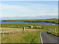
1
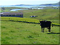
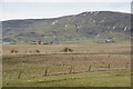
Dairy Cow by Aithsetter
Grassy fields with scattered houses and animals. Aith Voe is in the distance.
Image: © Colin Smith
Taken: 23 Jul 2010
0.07 miles
2
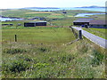
Fields at Aithsetter
Grassy fields with wire fencing and a few modern houses on the hillside above Aith Voe.
Image: © Colin Smith
Taken: 23 Jul 2010
0.11 miles
3
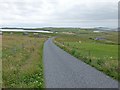
The road to Aith
Looking down the hill from Aithsetter.
Image: © John Allan
Taken: 1 Aug 2013
0.12 miles
4
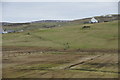
Aith Meadows, Cunningsburgh
Looking towards Gord.
Image: © Mike Pennington
Taken: 8 Feb 2010
0.18 miles
5
Aith Meadows, Cunningsburgh
Looking towards the hill of Hoo Field.
Image: © Mike Pennington
Taken: 8 Feb 2010
0.21 miles
7

Hay meadow, Aith
These traditional hay meadows are an increasingly rare sight. The yellow is Hawkbit, and additional colour is given by Red Clover and blue Scabious
Image: © Tim Harrison
Taken: 25 Jul 2005
0.24 miles